Olecko geodata
Olecko (Warmia-Masuria) is a seat of a third-order administrative division; located in Poland in Europe/Warsaw (GMT+2) time zone. With population of 15,923 people, there are 312 cities with bigger population in this country. Compared to other cities in Poland, 94.5% of cities are located further ↓South; 91.7% of cities are located further ←West and 56.4% of cities have higher elevation than Olecko. Note1


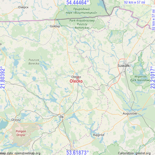
Olecko GPS coordinates[2]
54° 2' 1.464" North, 22° 30' 25.344" East
| Map corner | latitude | longitude |
|---|---|---|
| Upper-left | 54.44464°, | 21.80392° |
| Center: | 54.03374°, | 22.50704° |
| Lower-right: | 53.61873°, | 23.21017° |
| Map W x H: | 91.8×91.8 km | = 57×57mi |
| max Lat: | 54.83135° ⇑5.5% North |
| Olecko: | 54.03374° |
| min Lat: | ⇓94.5% South 49.21328° |
| min Long | Olecko | max Long |
| 14.20249° | 22.50704° | 24.03723° |
| W 91.7%⇐ | ⇒8.3% E |
Elevation
Elevation of Olecko is 155 m = 509 ft, and this is 36.4 m = 119 ft below average elevation for this country.
| Max E: |
974 m = 3196 ft | 56.4% |
| Avg. | 191.4 m = 628 ft | |
| Olecko | 155 m = 509 ft | |
Min E: |
-3 m = -10 ft | 43.6% |
See also: Poland elevation on elevation.city.
Geographical zone
Olecko is located in North temperate zone (between Tropic of Cancer and the Arctic Circle). Distance of this North polar circle is 1393.2 km =865.7 mi to North.| Distance of | km | miles | from Olecko |
|---|---|---|---|
| North Pole | 3999.1 | 2484.9 | to North |
| Arctic Circle | 1393.2 | 865.7 | to North |
| Tropic Cancer | 3402.1 | 2114 | to South |
| Equator | 6008 | 3733.2 | to South |


Nearby cities:
15 places around Olecko: (largest is in red/bold)
• Bakałarzewo
11.6 km =7.2 mi,  54°
54°
• Dubeninki
28.5 km =17.7 mi,  6°
6°
• Ełk
24.7 km =15.3 mi,  202°
202°
• Filipów
17.9 km =11.1 mi,  24°
24°
• Grabowo
27.5 km =17.1 mi,  320°
320°
• Jeleniewo
32.6 km =20.3 mi, 54°
• Kalinowo
20.7 km =12.9 mi,  148°
148°
• Kowale Oleckie
15.6 km =9.7 mi,  337°
337°
• Przerośl
26.2 km =16.3 mi, 22°
• Raczki
18.9 km =11.7 mi,  105°
105°
• Stare Juchy
25.1 km =15.6 mi,  240°
240°
• Suwałki
29 km =18 mi,  72°
72°
• Swiętajno
12.8 km =8 mi,  253°
253°
• Wieliczki
6.5 km =4 mi, 146°
• Wydminy
31.5 km =19.6 mi,  259°
259°
Sources, notices
• [Note1] Compared only with cities in Poland existing in our database
• [Src1] Map data: © OpenStreetMap contributors (CC-BY-SA)
• [Src2] Other city data from geonames.org with taken over terms of usage.
• [Src3] Geographical zone / Annual Mean Temperature by Robert A. Rohde @ Wikipedia
