Ełk geodata
Ełk (Warmia-Masuria) is a seat of a second-order administrative division; located in Poland in Europe/Warsaw (GMT+2) time zone. With population of 55,769 people, there are 92 cities with bigger population in this country. Compared to other cities in Poland, 92.5% of cities are located further ↓South; 89.7% of cities are located further ←West and 67.4% of cities have higher elevation than Ełk. Note1


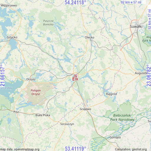
Ełk GPS coordinates[2]
53° 49' 41.664" North, 22° 21' 52.884" East
| Map corner | latitude | longitude |
|---|---|---|
| Upper-left | 54.24118°, | 21.66157° |
| Center: | 53.82824°, | 22.36469° |
| Lower-right: | 53.41119°, | 23.06782° |
| Map W x H: | 92.3×92.3 km | = 57.4×57.4mi |
| max Lat: | 54.83135° ⇑7.5% North |
| Ełk: | 53.82824° |
| min Lat: | ⇓92.5% South 49.21328° |
| min Long | Ełk | max Long |
| 14.20249° | 22.36469° | 24.03723° |
| W 89.7%⇐ | ⇒10.3% E |
Elevation
Elevation of Ełk is 127 m = 417 ft, and this is 64.4 m = 211 ft below average elevation for this country.
| Max E: |
974 m = 3196 ft | 67.4% |
| Avg. | 191.4 m = 628 ft | |
| Ełk | 127 m = 417 ft | |
Min E: |
-3 m = -10 ft | 32.6% |
See also: Ełk elevation on elevation.city.
Geographical zone
Ełk is located in North temperate zone (between Tropic of Cancer and the Arctic Circle). Distance of this North polar circle is 1416 km =879.9 mi to North.| Distance of | km | miles | from Ełk |
|---|---|---|---|
| North Pole | 4021.9 | 2499.1 | to North |
| Arctic Circle | 1416 | 879.9 | to North |
| Tropic Cancer | 3379.2 | 2099.7 | to South |
| Equator | 5985.1 | 3719 | to South |


Nearby cities:
15 places around Ełk: (largest is in red/bold)
• Bargłów Kościelny
30.7 km =19.1 mi,  101°
101°
• Biała Piska
31.2 km =19.4 mi,  219°
219°
• Grajewo
21 km =13 mi,  163°
163°
• Kalinowo
20.8 km =12.9 mi,  75°
75°
• Miłki
34 km =21.1 mi,  292°
292°
• Olecko
24.7 km =15.3 mi,  22°
22°
• Orzysz
27.4 km =17 mi,  265°
265°
• Prostki
15 km =9.3 mi, 162°
• Raczki
32.7 km =20.3 mi,  57°
57°
• Rajgród
24.8 km =15.4 mi,  115°
115°
• Stare Juchy
16.3 km =10.1 mi,  309°
309°
• Swiętajno
19.5 km =12.1 mi,  351°
351°
• Szczuczyn
29.9 km =18.6 mi,  190°
190°
• Wieliczki
21.7 km =13.5 mi,  36°
36°
• Wydminy
27.7 km =17.2 mi, 308°
Sources, notices
• [Note1] Compared only with cities in Poland existing in our database
• [Src1] Map data: © OpenStreetMap contributors (CC-BY-SA)
• [Src2] Other city data from geonames.org with taken over terms of usage.
• [Src3] Geographical zone / Annual Mean Temperature by Robert A. Rohde @ Wikipedia
