Włodawa geodata
Włodawa (Lublin) is a seat of a third-order administrative division; located in Poland in Europe/Warsaw (GMT+2) time zone. With population of 13,142 people, there are 369 cities with bigger population in this country. Compared to other cities in Poland, 57.1% of cities are located further ↓South; 99% of cities are located further ←West and 50.6% of cities have lower elevation than Włodawa. Note1


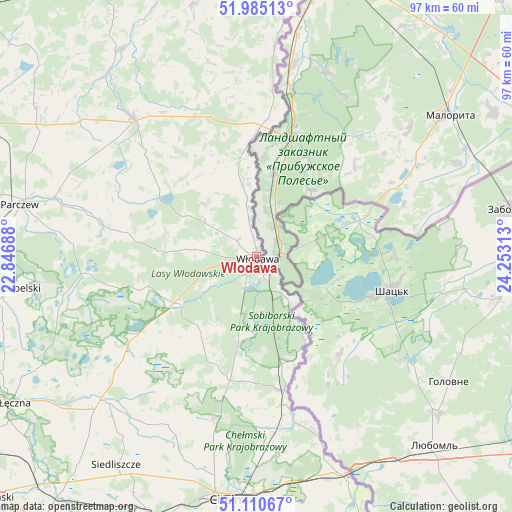
Włodawa GPS coordinates[2]
51° 33' 0" North, 23° 33' 0" East
| Map corner | latitude | longitude |
|---|---|---|
| Upper-left | 51.98513°, | 22.84688° |
| Center: | 51.55°, | 23.55° |
| Lower-right: | 51.11067°, | 24.25313° |
| Map W x H: | 97.2×97.2 km | = 60.4×60.4mi |
| max Lat: | 54.83135° ⇑42.9% North |
| Włodawa: | 51.55° |
| min Lat: | ⇓57.1% South 49.21328° |
| min Long | Włodawa | max Long |
| 14.20249° | 23.55° | 24.03723° |
| W 99%⇐ | ⇒1% E |
Elevation
Elevation of Włodawa is 173 m = 568 ft, and this is 18.4 m = 60 ft below average elevation for this country.
| Max E: |
974 m = 3196 ft | 49.4% |
| Avg. | 191.4 m = 628 ft | |
| Włodawa | 173 m = 568 ft | |
Min E: |
-3 m = -10 ft | 50.6% |
See also: Poland elevation on elevation.city.
Geographical zone
Włodawa is located in North temperate zone (between Tropic of Cancer and the Arctic Circle). Distance of this North polar circle is 1669.4 km =1037.3 mi to North.| Distance of | km | miles | from Włodawa |
|---|---|---|---|
| North Pole | 4275.2 | 2656.5 | to North |
| Arctic Circle | 1669.4 | 1037.3 | to North |
| Tropic Cancer | 3125.9 | 1942.3 | to South |
| Equator | 5731.8 | 3561.6 | to South |


Nearby cities:
15 places around Włodawa: (largest is in red/bold)
• Dębowa Kłoda
37.9 km =23.5 mi,  277°
277°
• Hanna
19 km =11.8 mi,  350°
350°
• Hańsk
18.5 km =11.5 mi,  214°
214°
• Jabłoń
37.4 km =23.2 mi,  301°
301°
• Podedwórze
28.7 km =17.8 mi, 302°
• Ruda-Huta
35 km =21.7 mi,  174°
174°
• Sawin
31.7 km =19.7 mi,  194°
194°
• Siedliszcze
30.5 km =19 mi, 168°
• Sosnowica
31.8 km =19.8 mi,  264°
264°
• Sosnówka
26.7 km =16.6 mi,  326°
326°
• Sławatycze
23.7 km =14.7 mi,  0°
0°
• Tuczna
37.7 km =23.4 mi, 346°
• Urszulin
30.1 km =18.7 mi,  234°
234°
• Wisznice
35.5 km =22.1 mi,  318°
318°
• Wola Uhruska
26 km =16.2 mi, 168°
Sources, notices
• [Note1] Compared only with cities in Poland existing in our database
• [Src1] Map data: © OpenStreetMap contributors (CC-BY-SA)
• [Src2] Other city data from geonames.org with taken over terms of usage.
• [Src3] Geographical zone / Annual Mean Temperature by Robert A. Rohde @ Wikipedia
