Wola Uhruska geodata
Wola Uhruska (Lublin) is a seat of a third-order administrative division; located in Poland in Europe/Warsaw (GMT+2) time zone. With population of 1,639 people, there are 1726 cities with bigger population in this country. Compared to other cities in Poland, 53.6% of cities are located further ↓South; 99.3% of cities are located further ←West and 50.8% of cities have lower elevation than Wola Uhruska. Note1


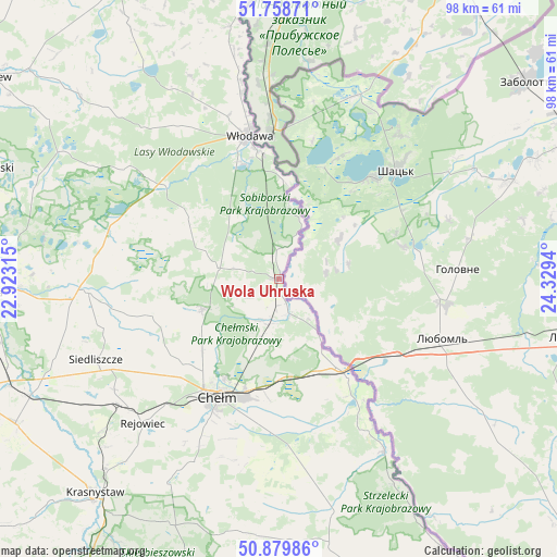
Wola Uhruska GPS coordinates[2]
51° 19' 17.004" North, 23° 37' 34.572" East
| Map corner | latitude | longitude |
|---|---|---|
| Upper-left | 51.75871°, | 22.92315° |
| Center: | 51.32139°, | 23.62627° |
| Lower-right: | 50.87986°, | 24.3294° |
| Map W x H: | 97.7×97.7 km | = 60.7×60.7mi |
| max Lat: | 54.83135° ⇑46.4% North |
| Wola Uhruska: | 51.32139° |
| min Lat: | ⇓53.6% South 49.21328° |
| min Long | Wola Uhruska | max Long |
| 14.20249° | 23.62627° | 24.03723° |
| W 99.3%⇐ | ⇒0.7% E |
Elevation
Elevation of Wola Uhruska is 174 m = 571 ft, and this is 17.4 m = 57 ft below average elevation for this country.
| Max E: |
974 m = 3196 ft | 49.2% |
| Avg. | 191.4 m = 628 ft | |
| Wola Uhruska | 174 m = 571 ft | |
Min E: |
-3 m = -10 ft | 50.8% |
See also: Poland elevation on elevation.city.
Geographical zone
Wola Uhruska is located in North temperate zone (between Tropic of Cancer and the Arctic Circle). Distance of this North polar circle is 1694.8 km =1053.1 mi to North.| Distance of | km | miles | from Wola Uhruska |
|---|---|---|---|
| North Pole | 4300.7 | 2672.3 | to North |
| Arctic Circle | 1694.8 | 1053.1 | to North |
| Tropic Cancer | 3100.5 | 1926.6 | to South |
| Equator | 5706.4 | 3545.8 | to South |


Nearby cities:
15 places around Wola Uhruska: (largest is in red/bold)
• Chełm
22.6 km =14 mi,  208°
208°
• Cyców
33.8 km =21 mi,  265°
265°
• Dorohusk
22.3 km =13.9 mi,  146°
146°
• Dorohusk-Osada
20.4 km =12.7 mi, 145°
• Hańsk
18.7 km =11.6 mi,  302°
302°
• Kamień
25.2 km =15.7 mi,  186°
186°
• Pawłów
34.8 km =21.6 mi,  236°
236°
• Pokrówka
27.6 km =17.1 mi,  204°
204°
• Ruda-Huta
9.7 km =6 mi, 193°
• Sawin
14.4 km =8.9 mi,  248°
248°
• Siedliszcze
4.5 km =2.8 mi,  170°
170°
• Urszulin
31 km =19.3 mi,  285°
285°
• Włodawa
26 km =16.2 mi,  348°
348°
• Świerże
13.9 km =8.6 mi, 146°
• Żmudź
33.9 km =21.1 mi, 174°
Sources, notices
• [Note1] Compared only with cities in Poland existing in our database
• [Src1] Map data: © OpenStreetMap contributors (CC-BY-SA)
• [Src2] Other city data from geonames.org with taken over terms of usage.
• [Src3] Geographical zone / Annual Mean Temperature by Robert A. Rohde @ Wikipedia
