Siedliszcze geodata
Siedliszcze (Lublin) is a populated place; located in Poland in Europe/Warsaw (GMT+2) time zone. With population of 860 people, there are 2749 cities with bigger population in this country. Compared to other cities in Poland, 52.8% of cities are located further ↓South; 99.3% of cities are located further ←West and 55.2% of cities have lower elevation than Siedliszcze. Note1


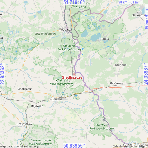
Siedliszcze GPS coordinates[2]
51° 16' 53.256" North, 23° 38' 12.264" East
| Map corner | latitude | longitude |
|---|---|---|
| Upper-left | 51.71916°, | 22.93362° |
| Center: | 51.28146°, | 23.63674° |
| Lower-right: | 50.83955°, | 24.33987° |
| Map W x H: | 97.8×97.8 km | = 60.8×60.8mi |
| max Lat: | 54.83135° ⇑47.2% North |
| Siedliszcze: | 51.28146° |
| min Lat: | ⇓52.8% South 49.21328° |
| min Long | Siedliszcze | max Long |
| 14.20249° | 23.63674° | 24.03723° |
| W 99.3%⇐ | ⇒0.7% E |
Elevation
Elevation of Siedliszcze is 186 m = 610 ft, and this is 5.4 m = 18 ft below average elevation for this country.
| Max E: |
974 m = 3196 ft | 44.8% |
| Avg. | 191.4 m = 628 ft | |
| Siedliszcze | 186 m = 610 ft | |
Min E: |
-3 m = -10 ft | 55.2% |
See also: Poland elevation on elevation.city.
Geographical zone
Siedliszcze is located in North temperate zone (between Tropic of Cancer and the Arctic Circle). Distance of this North polar circle is 1699.2 km =1055.8 mi to North.| Distance of | km | miles | from Siedliszcze |
|---|---|---|---|
| North Pole | 4305.1 | 2675.1 | to North |
| Arctic Circle | 1699.2 | 1055.8 | to North |
| Tropic Cancer | 3096 | 1923.8 | to South |
| Equator | 5702 | 3543.1 | to South |


Nearby cities:
15 places around Siedliszcze: (largest is in red/bold)
• Chełm
19.2 km =11.9 mi,  216°
216°
• Dorohusk
18.2 km =11.3 mi,  140°
140°
• Dorohusk-Osada
16.4 km =10.2 mi, 138°
• Dubienka
31.4 km =19.5 mi,  145°
145°
• Hańsk
22 km =13.7 mi,  311°
311°
• Kamień
20.9 km =13 mi,  189°
189°
• Pokrówka
24 km =14.9 mi,  210°
210°
• Rejowiec
32.5 km =20.2 mi,  229°
229°
• Rejowiec Fabryczny
32.9 km =20.4 mi,  235°
235°
• Ruda-Huta
5.8 km =3.6 mi, 210°
• Sawin
14.1 km =8.8 mi,  266°
266°
• Wola Uhruska
4.5 km =2.8 mi,  350°
350°
• Włodawa
30.5 km =19 mi, 348°
• Świerże
9.9 km =6.2 mi, 136°
• Żmudź
29.4 km =18.3 mi,  174°
174°
Sources, notices
• [Note1] Compared only with cities in Poland existing in our database
• [Src1] Map data: © OpenStreetMap contributors (CC-BY-SA)
• [Src2] Other city data from geonames.org with taken over terms of usage.
• [Src3] Geographical zone / Annual Mean Temperature by Robert A. Rohde @ Wikipedia
