Wiśniew geodata
Wiśniew (Mazovia) is a seat of a third-order administrative division; located in Poland in Europe/Warsaw (GMT+2) time zone. With population of 870 people, there are 2725 cities with bigger population in this country. Compared to other cities in Poland, 67% of cities are located further ↓South; 88.7% of cities are located further ←West and 55.3% of cities have higher elevation than Wiśniew. Note1


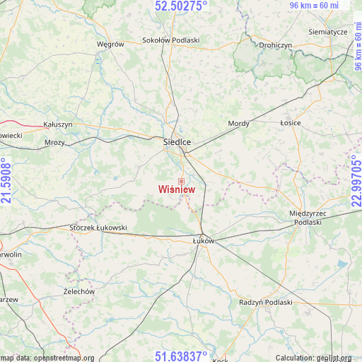
Wiśniew GPS coordinates[2]
52° 4' 21.54" North, 22° 17' 38.112" East
| Map corner | latitude | longitude |
|---|---|---|
| Upper-left | 52.50275°, | 21.5908° |
| Center: | 52.07265°, | 22.29392° |
| Lower-right: | 51.63837°, | 22.99705° |
| Map W x H: | 96.1×96.1 km | = 59.7×59.7mi |
| max Lat: | 54.83135° ⇑33% North |
| Wiśniew: | 52.07265° |
| min Lat: | ⇓67% South 49.21328° |
| min Long | Wiśniew | max Long |
| 14.20249° | 22.29392° | 24.03723° |
| W 88.7%⇐ | ⇒11.3% E |
Elevation
Elevation of Wiśniew is 158 m = 518 ft, and this is 33.4 m = 110 ft below average elevation for this country.
| Max E: |
974 m = 3196 ft | 55.3% |
| Avg. | 191.4 m = 628 ft | |
| Wiśniew | 158 m = 518 ft | |
Min E: |
-3 m = -10 ft | 44.7% |
See also: Poland elevation on elevation.city.
Geographical zone
Wiśniew is located in North temperate zone (between Tropic of Cancer and the Arctic Circle). Distance of this North polar circle is 1611.2 km =1001.2 mi to North.| Distance of | km | miles | from Wiśniew |
|---|---|---|---|
| North Pole | 4217.1 | 2620.4 | to North |
| Arctic Circle | 1611.2 | 1001.2 | to North |
| Tropic Cancer | 3184 | 1978.4 | to South |
| Equator | 5789.9 | 3597.7 | to South |


Nearby cities:
15 places around Wiśniew: (largest is in red/bold)
• Domanice
8.9 km =5.5 mi,  243°
243°
• Kotuń
19.3 km =12 mi,  306°
306°
• Mokobody
24.8 km =15.4 mi,  329°
329°
• Mordy
21.7 km =13.5 mi,  44°
44°
• Paprotnia
28 km =17.4 mi,  25°
25°
• Sarnów
24 km =14.9 mi,  178°
178°
• Siedlce
10.6 km =6.6 mi,  358°
358°
• Skórzec
11.8 km =7.3 mi,  289°
289°
• Stanin
23.4 km =14.5 mi,  195°
195°
• Stoczek Łukowski
25.3 km =15.7 mi, 240°
• Suchożebry
21 km =13 mi,  352°
352°
• Trzebieszów
20.1 km =12.5 mi,  117°
117°
• Wodynie
23.4 km =14.5 mi,  261°
261°
• Zbuczyn
10 km =6.2 mi,  79°
79°
• Łuków
17 km =10.6 mi,  159°
159°
Sources, notices
• [Note1] Compared only with cities in Poland existing in our database
• [Src1] Map data: © OpenStreetMap contributors (CC-BY-SA)
• [Src2] Other city data from geonames.org with taken over terms of usage.
• [Src3] Geographical zone / Annual Mean Temperature by Robert A. Rohde @ Wikipedia
