Siedlce geodata
Siedlce (Mazovia) is a populated place; located in Poland in Europe/Warsaw (GMT+2) time zone. With population of 77,185 people, there are 60 cities with bigger population in this country. Compared to other cities in Poland, 69.3% of cities are located further ↓South; 88.7% of cities are located further ←West and 58.4% of cities have higher elevation than Siedlce. Note1


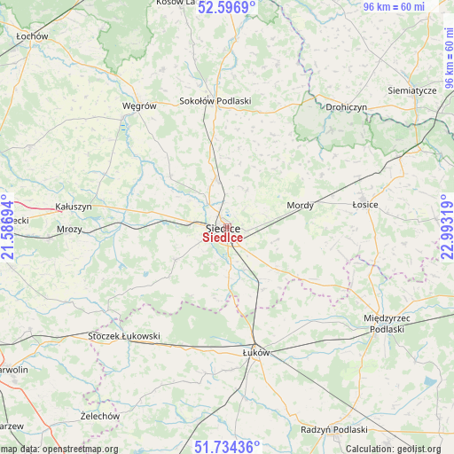
Siedlce GPS coordinates[2]
52° 10' 3.792" North, 22° 17' 24.216" East
| Map corner | latitude | longitude |
|---|---|---|
| Upper-left | 52.5969°, | 21.58694° |
| Center: | 52.16772°, | 22.29006° |
| Lower-right: | 51.73436°, | 22.99319° |
| Map W x H: | 95.9×95.9 km | = 59.6×59.6mi |
| max Lat: | 54.83135° ⇑30.7% North |
| Siedlce: | 52.16772° |
| min Lat: | ⇓69.3% South 49.21328° |
| min Long | Siedlce | max Long |
| 14.20249° | 22.29006° | 24.03723° |
| W 88.7%⇐ | ⇒11.3% E |
Elevation
Elevation of Siedlce is 150 m = 492 ft, and this is 41.4 m = 136 ft below average elevation for this country.
| Max E: |
974 m = 3196 ft | 58.4% |
| Avg. | 191.4 m = 628 ft | |
| Siedlce | 150 m = 492 ft | |
Min E: |
-3 m = -10 ft | 41.6% |
See also: Siedlce elevation on elevation.city.
Geographical zone
Siedlce is located in North temperate zone (between Tropic of Cancer and the Arctic Circle). Distance of this North polar circle is 1600.7 km =994.6 mi to North.| Distance of | km | miles | from Siedlce |
|---|---|---|---|
| North Pole | 4206.6 | 2613.9 | to North |
| Arctic Circle | 1600.7 | 994.6 | to North |
| Tropic Cancer | 3194.6 | 1985 | to South |
| Equator | 5800.5 | 3604.3 | to South |


Nearby cities:
15 places around Siedlce: (largest is in red/bold)
• Bielany
19.5 km =12.1 mi,  351°
351°
• Domanice
16.4 km =10.2 mi,  208°
208°
• Kotuń
15.2 km =9.4 mi,  273°
273°
• Mokobody
16.3 km =10.1 mi,  311°
311°
• Mordy
16.2 km =10.1 mi,  72°
72°
• Paprotnia
19.1 km =11.9 mi,  39°
39°
• Przesmyki
22.9 km =14.2 mi,  60°
60°
• Repki
25.2 km =15.7 mi,  15°
15°
• Skórzec
12.8 km =8 mi,  238°
238°
• Sokołów Podlaski
26.7 km =16.6 mi, 354°
• Suchożebry
10.5 km =6.5 mi, 346°
• Trzebieszów
26.8 km =16.7 mi,  137°
137°
• Wiśniew
10.6 km =6.6 mi,  178°
178°
• Wodynie
26.9 km =16.7 mi, 238°
• Zbuczyn
13.3 km =8.3 mi,  130°
130°
Sources, notices
• [Note1] Compared only with cities in Poland existing in our database
• [Src1] Map data: © OpenStreetMap contributors (CC-BY-SA)
• [Src2] Other city data from geonames.org with taken over terms of usage.
• [Src3] Geographical zone / Annual Mean Temperature by Robert A. Rohde @ Wikipedia
