Łuków geodata
Łuków (Lublin) is a seat of a third-order administrative division; located in Poland in Europe/Warsaw (GMT+2) time zone. With population of 30,465 people, there are 161 cities with bigger population in this country. Compared to other cities in Poland, 64.3% of cities are located further ↓South; 89.9% of cities are located further ←West and 54.9% of cities have higher elevation than Łuków. Note1


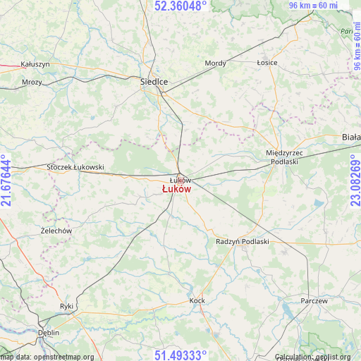
Łuków GPS coordinates[2]
51° 55' 44.4" North, 22° 22' 46.416" East
| Map corner | latitude | longitude |
|---|---|---|
| Upper-left | 52.36048°, | 21.67644° |
| Center: | 51.929°, | 22.37956° |
| Lower-right: | 51.49333°, | 23.08269° |
| Map W x H: | 96.4×96.4 km | = 59.9×59.9mi |
| max Lat: | 54.83135° ⇑35.7% North |
| Łuków: | 51.929° |
| min Lat: | ⇓64.3% South 49.21328° |
| min Long | Łuków | max Long |
| 14.20249° | 22.37956° | 24.03723° |
| W 89.9%⇐ | ⇒10.1% E |
Elevation
Elevation of Łuków is 159 m = 522 ft, and this is 32.4 m = 106 ft below average elevation for this country.
| Max E: |
974 m = 3196 ft | 54.9% |
| Avg. | 191.4 m = 628 ft | |
| Łuków | 159 m = 522 ft | |
Min E: |
-3 m = -10 ft | 45.1% |
See also: Poland elevation on elevation.city.
Geographical zone
Łuków is located in North temperate zone (between Tropic of Cancer and the Arctic Circle). Distance of this North polar circle is 1627.2 km =1011.1 mi to North.| Distance of | km | miles | from Łuków |
|---|---|---|---|
| North Pole | 4233.1 | 2630.3 | to North |
| Arctic Circle | 1627.2 | 1011.1 | to North |
| Tropic Cancer | 3168 | 1968.5 | to South |
| Equator | 5774 | 3587.8 | to South |


Nearby cities:
15 places around Łuków: (largest is in red/bold)
• Adamów
22.1 km =13.7 mi,  201°
201°
• Borki
25 km =15.5 mi,  157°
157°
• Bystrzyca
17.8 km =11.1 mi,  194°
194°
• Domanice
18.4 km =11.4 mi,  310°
310°
• Krzywda
19.3 km =12 mi,  219°
219°
• Kąkolewnica Wschodnia
22.6 km =14 mi,  96°
96°
• Radzyń Podlaski
23 km =14.3 mi,  134°
134°
• Rzeczyca
25.6 km =15.9 mi,  81°
81°
• Sarnów
9.6 km =6 mi,  213°
213°
• Serokomla
25.6 km =15.9 mi, 187°
• Stanin
13.8 km =8.6 mi,  241°
241°
• Trzebieszów
13.8 km =8.6 mi,  60°
60°
• Wiśniew
17 km =10.6 mi,  339°
339°
• Wojcieszków
18.3 km =11.4 mi, 193°
• Zbuczyn
18.3 km =11.4 mi,  12°
12°
Sources, notices
• [Note1] Compared only with cities in Poland existing in our database
• [Src1] Map data: © OpenStreetMap contributors (CC-BY-SA)
• [Src2] Other city data from geonames.org with taken over terms of usage.
• [Src3] Geographical zone / Annual Mean Temperature by Robert A. Rohde @ Wikipedia
