Stoczek Łukowski geodata
Stoczek Łukowski (Lublin) is a seat of a third-order administrative division; located in Poland in Europe/Warsaw (GMT+2) time zone. With population of 2,718 people, there are 1154 cities with bigger population in this country. Compared to other cities in Poland, 64.9% of cities are located further ↓South; 84.6% of cities are located further ←West and 53.7% of cities have higher elevation than Stoczek Łukowski. Note1


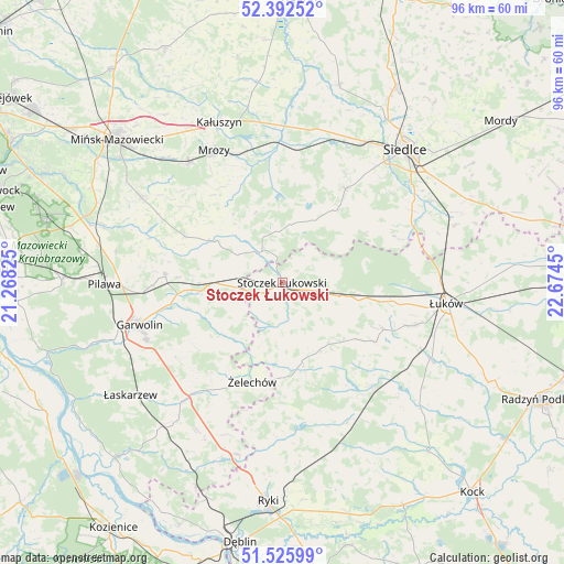
Stoczek Łukowski GPS coordinates[2]
51° 57' 40.86" North, 21° 58' 16.932" East
| Map corner | latitude | longitude |
|---|---|---|
| Upper-left | 52.39252°, | 21.26825° |
| Center: | 51.96135°, | 21.97137° |
| Lower-right: | 51.52599°, | 22.6745° |
| Map W x H: | 96.3×96.3 km | = 59.8×59.8mi |
| max Lat: | 54.83135° ⇑35.1% North |
| Stoczek Łukowski: | 51.96135° |
| min Lat: | ⇓64.9% South 49.21328° |
| min Long | Stoczek Łukows | max Long |
| 14.20249° | 21.97137° | 24.03723° |
| W 84.6%⇐ | ⇒15.4% E |
Elevation
Elevation of Stoczek Łukowski is 162 m = 531 ft, and this is 29.4 m = 96 ft below average elevation for this country.
| Max E: |
974 m = 3196 ft | 53.7% |
| Avg. | 191.4 m = 628 ft | |
| Stoczek Łukowski | 162 m = 531 ft | |
Min E: |
-3 m = -10 ft | 46.3% |
See also: Poland elevation on elevation.city.
Geographical zone
Stoczek Łukowski is located in North temperate zone (between Tropic of Cancer and the Arctic Circle). Distance of this North polar circle is 1623.6 km =1008.9 mi to North.| Distance of | km | miles | from Stoczek Łukowski |
|---|---|---|---|
| North Pole | 4229.5 | 2628.1 | to North |
| Arctic Circle | 1623.6 | 1008.9 | to North |
| Tropic Cancer | 3171.6 | 1970.7 | to South |
| Equator | 5777.6 | 3590 | to South |


Nearby cities:
15 places around Stoczek Łukowski: (largest is in red/bold)
• Borowie
14.2 km =8.8 mi,  264°
264°
• Domanice
16.4 km =10.2 mi,  58°
58°
• Górzno
22 km =13.7 mi,  234°
234°
• Kotuń
24.8 km =15.4 mi,  15°
15°
• Krzywda
24.2 km =15 mi,  139°
139°
• Latowicz
13.3 km =8.3 mi,  302°
302°
• Miastków Kościelny
13.2 km =8.2 mi, 229°
• Parysów
20 km =12.4 mi,  274°
274°
• Skórzec
19.5 km =12.1 mi,  33°
33°
• Stanin
18.8 km =11.7 mi,  122°
122°
• Sulbiny Górne
25.3 km =15.7 mi,  247°
247°
• Wielgolas
18.1 km =11.2 mi, 295°
• Wiśniew
25.3 km =15.7 mi, 60°
• Wodynie
8.9 km =5.5 mi,  353°
353°
• Żelechów
17.5 km =10.9 mi,  196°
196°
Sources, notices
• [Note1] Compared only with cities in Poland existing in our database
• [Src1] Map data: © OpenStreetMap contributors (CC-BY-SA)
• [Src2] Other city data from geonames.org with taken over terms of usage.
• [Src3] Geographical zone / Annual Mean Temperature by Robert A. Rohde @ Wikipedia
