Skórzec geodata
Skórzec (Mazovia) is a seat of a third-order administrative division; located in Poland in Europe/Warsaw (GMT+2) time zone. With population of 969 people, there are 2556 cities with bigger population in this country. Compared to other cities in Poland, 68% of cities are located further ↓South; 86.5% of cities are located further ←West and 54.2% of cities have higher elevation than Skórzec. Note1


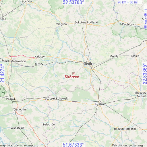
Skórzec GPS coordinates[2]
52° 6' 26.172" North, 22° 7' 49.872" East
| Map corner | latitude | longitude |
|---|---|---|
| Upper-left | 52.53703°, | 21.4274° |
| Center: | 52.10727°, | 22.13052° |
| Lower-right: | 51.67333°, | 22.83365° |
| Map W x H: | 96×96 km | = 59.7×59.7mi |
| max Lat: | 54.83135° ⇑32% North |
| Skórzec: | 52.10727° |
| min Lat: | ⇓68% South 49.21328° |
| min Long | Skórzec | max Long |
| 14.20249° | 22.13052° | 24.03723° |
| W 86.5%⇐ | ⇒13.5% E |
Elevation
Elevation of Skórzec is 161 m = 528 ft, and this is 30.4 m = 100 ft below average elevation for this country.
| Max E: |
974 m = 3196 ft | 54.2% |
| Avg. | 191.4 m = 628 ft | |
| Skórzec | 161 m = 528 ft | |
Min E: |
-3 m = -10 ft | 45.8% |
See also: Poland elevation on elevation.city.
Geographical zone
Skórzec is located in North temperate zone (between Tropic of Cancer and the Arctic Circle). Distance of this North polar circle is 1607.4 km =998.8 mi to North.| Distance of | km | miles | from Skórzec |
|---|---|---|---|
| North Pole | 4213.3 | 2618 | to North |
| Arctic Circle | 1607.4 | 998.8 | to North |
| Tropic Cancer | 3187.9 | 1980.9 | to South |
| Equator | 5793.8 | 3600.1 | to South |


Nearby cities:
15 places around Skórzec: (largest is in red/bold)
• Domanice
8.4 km =5.2 mi,  158°
158°
• Grębków
23.5 km =14.6 mi,  320°
320°
• Kałuszyn
24.6 km =15.3 mi,  296°
296°
• Kotuń
8.8 km =5.5 mi,  331°
331°
• Latowicz
23.8 km =14.8 mi,  247°
247°
• Mokobody
17.6 km =10.9 mi,  355°
355°
• Mrozy
23.3 km =14.5 mi,  286°
286°
• Siedlce
12.8 km =8 mi,  58°
58°
• Stanin
26.8 km =16.7 mi,  169°
169°
• Stoczek Łukowski
19.5 km =12.1 mi,  213°
213°
• Suchożebry
18.9 km =11.7 mi,  26°
26°
• Wiśniew
11.8 km =7.3 mi,  109°
109°
• Wodynie
14.1 km =8.8 mi,  238°
238°
• Zbuczyn
21.1 km =13.1 mi,  95°
95°
• Łuków
26.1 km =16.2 mi,  139°
139°
Sources, notices
• [Note1] Compared only with cities in Poland existing in our database
• [Src1] Map data: © OpenStreetMap contributors (CC-BY-SA)
• [Src2] Other city data from geonames.org with taken over terms of usage.
• [Src3] Geographical zone / Annual Mean Temperature by Robert A. Rohde @ Wikipedia
