Kotuń geodata
Kotuń (Mazovia) is a seat of a third-order administrative division; located in Poland in Europe/Warsaw (GMT+2) time zone. With population of 2,503 people, there are 1238 cities with bigger population in this country. Compared to other cities in Poland, 69.5% of cities are located further ↓South; 85.7% of cities are located further ←West and 58.4% of cities have higher elevation than Kotuń. Note1


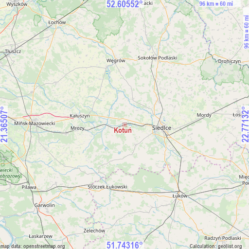
Kotuń GPS coordinates[2]
52° 10' 35.148" North, 22° 4' 5.484" East
| Map corner | latitude | longitude |
|---|---|---|
| Upper-left | 52.60552°, | 21.36507° |
| Center: | 52.17643°, | 22.06819° |
| Lower-right: | 51.74316°, | 22.77132° |
| Map W x H: | 95.9×95.9 km | = 59.6×59.6mi |
| max Lat: | 54.83135° ⇑30.5% North |
| Kotuń: | 52.17643° |
| min Lat: | ⇓69.5% South 49.21328° |
| min Long | Kotuń | max Long |
| 14.20249° | 22.06819° | 24.03723° |
| W 85.7%⇐ | ⇒14.3% E |
Elevation
Elevation of Kotuń is 150 m = 492 ft, and this is 41.4 m = 136 ft below average elevation for this country.
| Max E: |
974 m = 3196 ft | 58.4% |
| Avg. | 191.4 m = 628 ft | |
| Kotuń | 150 m = 492 ft | |
Min E: |
-3 m = -10 ft | 41.6% |
See also: Poland elevation on elevation.city.
Geographical zone
Kotuń is located in North temperate zone (between Tropic of Cancer and the Arctic Circle). Distance of this North polar circle is 1599.7 km =994 mi to North.| Distance of | km | miles | from Kotuń |
|---|---|---|---|
| North Pole | 4205.6 | 2613.2 | to North |
| Arctic Circle | 1599.7 | 994 | to North |
| Tropic Cancer | 3195.6 | 1985.7 | to South |
| Equator | 5801.5 | 3604.9 | to South |


Nearby cities:
15 places around Kotuń: (largest is in red/bold)
• Bielany
22.1 km =13.7 mi,  33°
33°
• Cegłów
22.8 km =14.2 mi,  261°
261°
• Domanice
17.1 km =10.6 mi,  154°
154°
• Grębków
14.9 km =9.3 mi,  313°
313°
• Kałuszyn
18 km =11.2 mi,  280°
280°
• Latowicz
24.4 km =15.2 mi,  226°
226°
• Liw
23.1 km =14.4 mi,  342°
342°
• Mokobody
10.3 km =6.4 mi,  16°
16°
• Mrozy
18.1 km =11.2 mi,  266°
266°
• Siedlce
15.2 km =9.4 mi,  93°
93°
• Skórzec
8.8 km =5.5 mi, 151°
• Suchożebry
15.6 km =9.7 mi,  53°
53°
• Wierzbno
20.6 km =12.8 mi,  316°
316°
• Wiśniew
19.3 km =12 mi,  126°
126°
• Wodynie
17 km =10.6 mi,  206°
206°
Sources, notices
• [Note1] Compared only with cities in Poland existing in our database
• [Src1] Map data: © OpenStreetMap contributors (CC-BY-SA)
• [Src2] Other city data from geonames.org with taken over terms of usage.
• [Src3] Geographical zone / Annual Mean Temperature by Robert A. Rohde @ Wikipedia
