Szczurowa geodata
Szczurowa (Lesser Poland) is a seat of a third-order administrative division; located in Poland in Europe/Warsaw (GMT+2) time zone. With population of 1,722 people, there are 1663 cities with bigger population in this country. Compared to other cities in Poland, 77.3% of cities are located further ↑North; 66.8% of cities are located further ←West and 53% of cities have lower elevation than Szczurowa. Note1


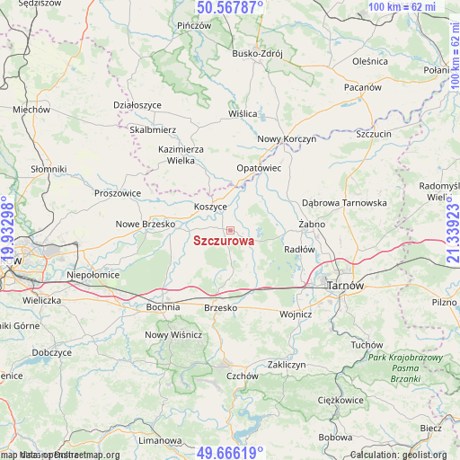
Szczurowa GPS coordinates[2]
50° 7' 8.94" North, 20° 38' 9.96" East
| Map corner | latitude | longitude |
|---|---|---|
| Upper-left | 50.56787°, | 19.93298° |
| Center: | 50.11915°, | 20.6361° |
| Lower-right: | 49.66619°, | 21.33923° |
| Map W x H: | 100.3×100.3 km | = 62.3×62.3mi |
| max Lat: | 54.83135° ⇑77.3% North |
| Szczurowa: | 50.11915° |
| min Lat: | ⇓22.7% South 49.21328° |
| min Long | Szczurowa | max Long |
| 14.20249° | 20.6361° | 24.03723° |
| W 66.8%⇐ | ⇒33.2% E |
Elevation
Elevation of Szczurowa is 180 m = 591 ft, and this is 11.4 m = 37 ft below average elevation for this country.
| Max E: |
974 m = 3196 ft | 47% |
| Avg. | 191.4 m = 628 ft | |
| Szczurowa | 180 m = 591 ft | |
Min E: |
-3 m = -10 ft | 53% |
See also: Poland elevation on elevation.city.
Geographical zone
Szczurowa is located in North temperate zone (between Tropic of Cancer and the Arctic Circle). Distance of this North polar circle is 1828.4 km =1136.1 mi to North.| Distance of | km | miles | from Szczurowa |
|---|---|---|---|
| North Pole | 4434.3 | 2755.3 | to North |
| Arctic Circle | 1828.4 | 1136.1 | to North |
| Tropic Cancer | 2966.8 | 1843.5 | to South |
| Equator | 5572.7 | 3462.7 | to South |


Nearby cities:
15 places around Szczurowa: (largest is in red/bold)
• Borzęcin
8 km =5 mi,  138°
138°
• Jadowniki Mokre
8.4 km =5.2 mi,  51°
51°
• Koszyce
7 km =4.3 mi,  324°
324°
• Miechowice Małe
11 km =6.8 mi,  59°
59°
• Miechowice Wielkie
11.1 km =6.9 mi,  43°
43°
• Przyborów
10.1 km =6.3 mi,  169°
169°
• Przybysławice
12.7 km =7.9 mi,  68°
68°
• Rudy-Rysie
6.4 km =4 mi,  178°
178°
• Strzelce Wielkie
4.8 km =3 mi,  234°
234°
• Szczepanów
12.7 km =7.9 mi, 174°
• Uście Solne
8.7 km =5.4 mi,  270°
270°
• Wietrzychowice
12.2 km =7.6 mi, 48°
• Wokowice
13.4 km =8.3 mi,  159°
159°
• Zabawa
13.3 km =8.3 mi,  89°
89°
• Zaborów
4.9 km =3 mi, 51°
Sources, notices
• [Note1] Compared only with cities in Poland existing in our database
• [Src1] Map data: © OpenStreetMap contributors (CC-BY-SA)
• [Src2] Other city data from geonames.org with taken over terms of usage.
• [Src3] Geographical zone / Annual Mean Temperature by Robert A. Rohde @ Wikipedia
