Tykocin geodata
Tykocin (Podlasie) is a seat of a third-order administrative division; located in Poland in Europe/Warsaw (GMT+2) time zone. With population of 1,907 people, there are 1547 cities with bigger population in this country. Compared to other cities in Poland, 86.6% of cities are located further ↓South; 94.4% of cities are located further ←West and 75.4% of cities have higher elevation than Tykocin. Note1


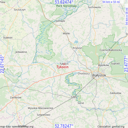
Tykocin GPS coordinates[2]
53° 12' 20.412" North, 22° 46' 28.452" East
| Map corner | latitude | longitude |
|---|---|---|
| Upper-left | 53.62474°, | 22.07145° |
| Center: | 53.20567°, | 22.77457° |
| Lower-right: | 52.78247°, | 23.4777° |
| Map W x H: | 93.7×93.6 km | = 58.2×58.2mi |
| max Lat: | 54.83135° ⇑13.4% North |
| Tykocin: | 53.20567° |
| min Lat: | ⇓86.6% South 49.21328° |
| min Long | Tykocin | max Long |
| 14.20249° | 22.77457° | 24.03723° |
| W 94.4%⇐ | ⇒5.6% E |
Elevation
Elevation of Tykocin is 110 m = 361 ft, and this is 81.4 m = 267 ft below average elevation for this country.
| Max E: |
974 m = 3196 ft | 75.4% |
| Avg. | 191.4 m = 628 ft | |
| Tykocin | 110 m = 361 ft | |
Min E: |
-3 m = -10 ft | 24.6% |
See also: Poland elevation on elevation.city.
Geographical zone
Tykocin is located in North temperate zone (between Tropic of Cancer and the Arctic Circle). Distance of this North polar circle is 1485.3 km =922.9 mi to North.| Distance of | km | miles | from Tykocin |
|---|---|---|---|
| North Pole | 4091.1 | 2542.1 | to North |
| Arctic Circle | 1485.3 | 922.9 | to North |
| Tropic Cancer | 3310 | 2056.7 | to South |
| Equator | 5915.9 | 3676 | to South |


Nearby cities:
15 places around Tykocin: (largest is in red/bold)
• Białystok
27.2 km =16.9 mi,  107°
107°
• Choroszcz
15.9 km =9.9 mi,  115°
115°
• Dobrzyniewo Duże
15.8 km =9.8 mi,  92°
92°
• Jasionówka
27.4 km =17 mi,  39°
39°
• Knyszyn
15.4 km =9.6 mi, 38°
• Mońki
22.2 km =13.8 mi,  4°
4°
• Rutki
25.6 km =15.9 mi,  242°
242°
• Rutki-Kossaki
25.8 km =16 mi, 239°
• Sokoły
24.1 km =15 mi,  191°
191°
• Trzcianne
16.7 km =10.4 mi,  338°
338°
• Turośń Kościelna
28.3 km =17.6 mi,  138°
138°
• Wasilków
28.9 km =18 mi, 91°
• Wizna
26.1 km =16.2 mi,  267°
267°
• Złotoria
10.9 km =6.8 mi, 106°
• Łapy
25 km =15.5 mi,  162°
162°
Sources, notices
• [Note1] Compared only with cities in Poland existing in our database
• [Src1] Map data: © OpenStreetMap contributors (CC-BY-SA)
• [Src2] Other city data from geonames.org with taken over terms of usage.
• [Src3] Geographical zone / Annual Mean Temperature by Robert A. Rohde @ Wikipedia
