Sokoły geodata
Sokoły (Podlasie) is a populated place; located in Poland in Europe/Warsaw (GMT+2) time zone. With population of 1,450 people, there are 1914 cities with bigger population in this country. Compared to other cities in Poland, 83.5% of cities are located further ↓South; 93.8% of cities are located further ←West and 57.8% of cities have higher elevation than Sokoły. Note1


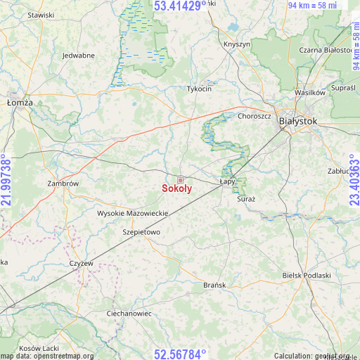
Sokoły GPS coordinates[2]
52° 59' 35.304" North, 22° 42' 1.8" East
| Map corner | latitude | longitude |
|---|---|---|
| Upper-left | 53.41429°, | 21.99738° |
| Center: | 52.99314°, | 22.7005° |
| Lower-right: | 52.56784°, | 23.40363° |
| Map W x H: | 94.1×94.1 km | = 58.5×58.5mi |
| max Lat: | 54.83135° ⇑16.5% North |
| Sokoły: | 52.99314° |
| min Lat: | ⇓83.5% South 49.21328° |
| min Long | Sokoły | max Long |
| 14.20249° | 22.7005° | 24.03723° |
| W 93.8%⇐ | ⇒6.2% E |
Elevation
Elevation of Sokoły is 151 m = 495 ft, and this is 40.4 m = 133 ft below average elevation for this country.
| Max E: |
974 m = 3196 ft | 57.8% |
| Avg. | 191.4 m = 628 ft | |
| Sokoły | 151 m = 495 ft | |
Min E: |
-3 m = -10 ft | 42.2% |
See also: Poland elevation on elevation.city.
Geographical zone
Sokoły is located in North temperate zone (between Tropic of Cancer and the Arctic Circle). Distance of this North polar circle is 1508.9 km =937.6 mi to North.| Distance of | km | miles | from Sokoły |
|---|---|---|---|
| North Pole | 4114.8 | 2556.8 | to North |
| Arctic Circle | 1508.9 | 937.6 | to North |
| Tropic Cancer | 3286.4 | 2042.1 | to South |
| Equator | 5892.3 | 3661.3 | to South |


Nearby cities:
15 places around Sokoły: (largest is in red/bold)
• Brańsk
29.2 km =18.1 mi,  161°
161°
• Choroszcz
25.5 km =15.8 mi,  49°
49°
• Klukowo
27.4 km =17 mi,  208°
208°
• Rudka
29.9 km =18.6 mi,  176°
176°
• Rutki
21.4 km =13.3 mi,  303°
303°
• Rutki-Kossaki
20.4 km =12.7 mi, 301°
• Suraż
17.8 km =11.1 mi,  105°
105°
• Szepietowo
17.2 km =10.7 mi,  217°
217°
• Turośń Kościelna
23.9 km =14.9 mi,  84°
84°
• Tykocin
24.1 km =15 mi,  11°
11°
• Wysokie Mazowieckie
14.9 km =9.3 mi,  235°
235°
• Wyszki
25.3 km =15.7 mi,  131°
131°
• Zambrów
30.6 km =19 mi,  268°
268°
• Złotoria
25.7 km =16 mi,  36°
36°
• Łapy
12.3 km =7.6 mi,  91°
91°
Sources, notices
• [Note1] Compared only with cities in Poland existing in our database
• [Src1] Map data: © OpenStreetMap contributors (CC-BY-SA)
• [Src2] Other city data from geonames.org with taken over terms of usage.
• [Src3] Geographical zone / Annual Mean Temperature by Robert A. Rohde @ Wikipedia
