Złotoria geodata
Złotoria (Podlasie) is a populated place; located in Poland in Europe/Warsaw (GMT+2) time zone. With population of 1,000 people, there are 2459 cities with bigger population in this country. Compared to other cities in Poland, 86.1% of cities are located further ↓South; 95.6% of cities are located further ←West and 70.4% of cities have higher elevation than Złotoria. Note1


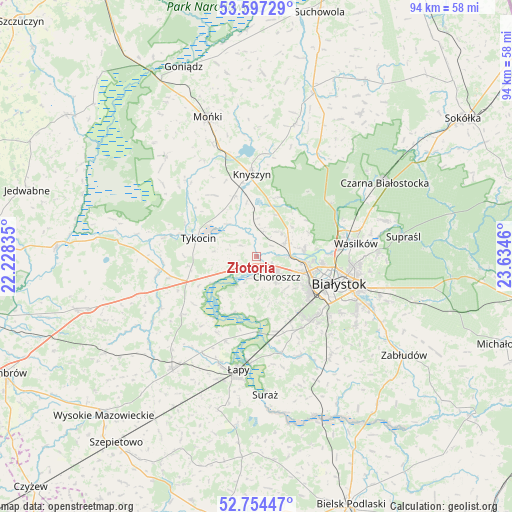
Złotoria GPS coordinates[2]
53° 10' 40.62" North, 22° 55' 53.292" East
| Map corner | latitude | longitude |
|---|---|---|
| Upper-left | 53.59729°, | 22.22835° |
| Center: | 53.17795°, | 22.93147° |
| Lower-right: | 52.75447°, | 23.6346° |
| Map W x H: | 93.7×93.7 km | = 58.2×58.2mi |
| max Lat: | 54.83135° ⇑13.9% North |
| Złotoria: | 53.17795° |
| min Lat: | ⇓86.1% South 49.21328° |
| min Long | Złotoria | max Long |
| 14.20249° | 22.93147° | 24.03723° |
| W 95.6%⇐ | ⇒4.4% E |
Elevation
Elevation of Złotoria is 120 m = 394 ft, and this is 71.4 m = 234 ft below average elevation for this country.
| Max E: |
974 m = 3196 ft | 70.4% |
| Avg. | 191.4 m = 628 ft | |
| Złotoria | 120 m = 394 ft | |
Min E: |
-3 m = -10 ft | 29.6% |
See also: Poland elevation on elevation.city.
Geographical zone
Złotoria is located in North temperate zone (between Tropic of Cancer and the Arctic Circle). Distance of this North polar circle is 1488.3 km =924.8 mi to North.| Distance of | km | miles | from Złotoria |
|---|---|---|---|
| North Pole | 4094.2 | 2544 | to North |
| Arctic Circle | 1488.3 | 924.8 | to North |
| Tropic Cancer | 3306.9 | 2054.8 | to South |
| Equator | 5912.8 | 3674 | to South |


Nearby cities:
15 places around Złotoria: (largest is in red/bold)
• Białystok
16.3 km =10.1 mi,  107°
107°
• Choroszcz
5.4 km =3.4 mi,  135°
135°
• Czarna Białostocka
27.2 km =16.9 mi,  58°
58°
• Dobrzyniewo Duże
5.9 km =3.7 mi,  65°
65°
• Jasionówka
25.2 km =15.7 mi,  16°
16°
• Knyszyn
15.2 km =9.4 mi,  357°
357°
• Mońki
26.8 km =16.7 mi,  340°
340°
• Sokoły
25.7 km =16 mi,  216°
216°
• Supraśl
27.3 km =17 mi,  83°
83°
• Suraż
25.5 km =15.8 mi,  176°
176°
• Trzcianne
24.9 km =15.5 mi,  318°
318°
• Turośń Kościelna
20 km =12.4 mi,  155°
155°
• Tykocin
10.9 km =6.8 mi,  286°
286°
• Wasilków
18.6 km =11.6 mi, 82°
• Łapy
21 km =13 mi,  188°
188°
Sources, notices
• [Note1] Compared only with cities in Poland existing in our database
• [Src1] Map data: © OpenStreetMap contributors (CC-BY-SA)
• [Src2] Other city data from geonames.org with taken over terms of usage.
• [Src3] Geographical zone / Annual Mean Temperature by Robert A. Rohde @ Wikipedia
