Jasionówka geodata
Jasionówka (Podlasie) is a populated place; located in Poland in Europe/Warsaw (GMT+2) time zone. With population of 860 people, there are 2749 cities with bigger population in this country. Compared to other cities in Poland, 88.5% of cities are located further ↓South; 96.4% of cities are located further ←West and 62.4% of cities have higher elevation than Jasionówka. Note1


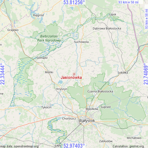
Jasionówka GPS coordinates[2]
53° 23' 43.296" North, 23° 2' 15.216" East
| Map corner | latitude | longitude |
|---|---|---|
| Upper-left | 53.81256°, | 22.33444° |
| Center: | 53.39536°, | 23.03756° |
| Lower-right: | 52.97403°, | 23.74069° |
| Map W x H: | 93.2×93.2 km | = 57.9×57.9mi |
| max Lat: | 54.83135° ⇑11.5% North |
| Jasionówka: | 53.39536° |
| min Lat: | ⇓88.5% South 49.21328° |
| min Long | Jasionówka | max Long |
| 14.20249° | 23.03756° | 24.03723° |
| W 96.4%⇐ | ⇒3.6% E |
Elevation
Elevation of Jasionówka is 141 m = 463 ft, and this is 50.4 m = 165 ft below average elevation for this country.
| Max E: |
974 m = 3196 ft | 62.4% |
| Avg. | 191.4 m = 628 ft | |
| Jasionówka | 141 m = 463 ft | |
Min E: |
-3 m = -10 ft | 37.6% |
See also: Poland elevation on elevation.city.
Geographical zone
Jasionówka is located in North temperate zone (between Tropic of Cancer and the Arctic Circle). Distance of this North polar circle is 1464.2 km =909.8 mi to North.| Distance of | km | miles | from Jasionówka |
|---|---|---|---|
| North Pole | 4070.1 | 2529 | to North |
| Arctic Circle | 1464.2 | 909.8 | to North |
| Tropic Cancer | 3331.1 | 2069.8 | to South |
| Equator | 5937 | 3689.1 | to South |


Nearby cities:
15 places around Jasionówka: (largest is in red/bold)
• Choroszcz
28.2 km =17.5 mi,  186°
186°
• Czarna Białostocka
19 km =11.8 mi,  121°
121°
• Dobrzyniewo Duże
21.8 km =13.5 mi,  184°
184°
• Goniadz
22.6 km =14 mi,  297°
297°
• Janów
15.1 km =9.4 mi,  57°
57°
• Jaświły
11.1 km =6.9 mi,  328°
328°
• Knyszyn
12 km =7.5 mi,  220°
220°
• Korycin
6.6 km =4.1 mi,  32°
32°
• Mońki
15.9 km =9.9 mi,  273°
273°
• Suchowola
20.8 km =12.9 mi,  12°
12°
• Supraśl
29.1 km =18.1 mi,  136°
136°
• Trzcianne
24.1 km =15 mi,  256°
256°
• Tykocin
27.4 km =17 mi, 219°
• Wasilków
24.6 km =15.3 mi,  152°
152°
• Złotoria
25.2 km =15.7 mi,  196°
196°
Sources, notices
• [Note1] Compared only with cities in Poland existing in our database
• [Src1] Map data: © OpenStreetMap contributors (CC-BY-SA)
• [Src2] Other city data from geonames.org with taken over terms of usage.
• [Src3] Geographical zone / Annual Mean Temperature by Robert A. Rohde @ Wikipedia
