Trzcianne geodata
Trzcianne (Podlasie) is a populated place; located in Poland in Europe/Warsaw (GMT+2) time zone. With population of 607 people, there are 3259 cities with bigger population in this country. Compared to other cities in Poland, 87.9% of cities are located further ↓South; 93.7% of cities are located further ←West and 69.8% of cities have higher elevation than Trzcianne. Note1


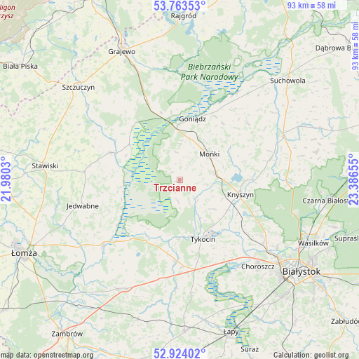
Trzcianne GPS coordinates[2]
53° 20' 45.024" North, 22° 41' 0.312" East
| Map corner | latitude | longitude |
|---|---|---|
| Upper-left | 53.76353°, | 21.9803° |
| Center: | 53.34584°, | 22.68342° |
| Lower-right: | 52.92402°, | 23.38655° |
| Map W x H: | 93.3×93.3 km | = 58×58mi |
| max Lat: | 54.83135° ⇑12.1% North |
| Trzcianne: | 53.34584° |
| min Lat: | ⇓87.9% South 49.21328° |
| min Long | Trzcianne | max Long |
| 14.20249° | 22.68342° | 24.03723° |
| W 93.7%⇐ | ⇒6.3% E |
Elevation
Elevation of Trzcianne is 121 m = 397 ft, and this is 70.4 m = 231 ft below average elevation for this country.
| Max E: |
974 m = 3196 ft | 69.8% |
| Avg. | 191.4 m = 628 ft | |
| Trzcianne | 121 m = 397 ft | |
Min E: |
-3 m = -10 ft | 30.2% |
See also: Poland elevation on elevation.city.
Geographical zone
Trzcianne is located in North temperate zone (between Tropic of Cancer and the Arctic Circle). Distance of this North polar circle is 1469.7 km =913.2 mi to North.| Distance of | km | miles | from Trzcianne |
|---|---|---|---|
| North Pole | 4075.6 | 2532.5 | to North |
| Arctic Circle | 1469.7 | 913.2 | to North |
| Tropic Cancer | 3325.6 | 2066.4 | to South |
| Equator | 5931.5 | 3685.7 | to South |


Nearby cities:
15 places around Trzcianne: (largest is in red/bold)
• Choroszcz
30.3 km =18.8 mi,  137°
137°
• Dobrzyniewo Duże
27.2 km =16.9 mi,  126°
126°
• Goniadz
16.3 km =10.1 mi,  12°
12°
• Jasionówka
24.1 km =15 mi,  76°
76°
• Jaświły
23.1 km =14.4 mi,  49°
49°
• Jedwabne
26.1 km =16.2 mi,  255°
255°
• Knyszyn
16.1 km =10 mi,  102°
102°
• Korycin
29.2 km =18.1 mi,  67°
67°
• Mońki
10 km =6.2 mi, 49°
• Radziłów
19.5 km =12.1 mi,  291°
291°
• Rutki
32 km =19.9 mi,  211°
211°
• Tykocin
16.7 km =10.4 mi,  158°
158°
• Wizna
26.1 km =16.2 mi,  230°
230°
• Wąsosz
31.1 km =19.3 mi,  309°
309°
• Złotoria
24.9 km =15.5 mi, 138°
Sources, notices
• [Note1] Compared only with cities in Poland existing in our database
• [Src1] Map data: © OpenStreetMap contributors (CC-BY-SA)
• [Src2] Other city data from geonames.org with taken over terms of usage.
• [Src3] Geographical zone / Annual Mean Temperature by Robert A. Rohde @ Wikipedia
