Rutki geodata
Rutki (Podlasie) is a seat of a third-order administrative division; located in Poland in Europe/Warsaw (GMT+2) time zone. In our database, there are 3649 cities with bigger population. Compared to other cities in Poland, 85% of cities are located further ↓South; 90.7% of cities are located further ←West and 72.1% of cities have higher elevation than Rutki. Note1


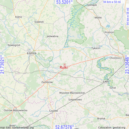
Rutki GPS coordinates[2]
53° 6' 0" North, 22° 25' 59.988" East
| Map corner | latitude | longitude |
|---|---|---|
| Upper-left | 53.5201°, | 21.73021° |
| Center: | 53.1°, | 22.43333° |
| Lower-right: | 52.67576°, | 23.13646° |
| Map W x H: | 93.9×93.9 km | = 58.3×58.3mi |
| max Lat: | 54.83135° ⇑15% North |
| Rutki: | 53.1° |
| min Lat: | ⇓85% South 49.21328° |
| min Long | Rutki | max Long |
| 14.20249° | 22.43333° | 24.03723° |
| W 90.7%⇐ | ⇒9.3% E |
Elevation
Elevation of Rutki is 117 m = 384 ft, and this is 74.4 m = 244 ft below average elevation for this country.
| Max E: |
974 m = 3196 ft | 72.1% |
| Avg. | 191.4 m = 628 ft | |
| Rutki | 117 m = 384 ft | |
Min E: |
-3 m = -10 ft | 27.9% |
See also: Poland elevation on elevation.city.
Geographical zone
Rutki is located in North temperate zone (between Tropic of Cancer and the Arctic Circle). Distance of this North polar circle is 1497 km =930.2 mi to North.| Distance of | km | miles | from Rutki |
|---|---|---|---|
| North Pole | 4102.9 | 2549.4 | to North |
| Arctic Circle | 1497 | 930.2 | to North |
| Tropic Cancer | 3298.2 | 2049.4 | to South |
| Equator | 5904.2 | 3668.7 | to South |


Nearby cities:
15 places around Rutki: (largest is in red/bold)
• Czarnocin
26.9 km =16.7 mi,  298°
298°
• Gać
12.7 km =7.9 mi,  259°
259°
• Jedwabne
22.4 km =13.9 mi,  337°
337°
• Piątnica
24.9 km =15.5 mi, 295°
• Rutki-Kossaki
1.3 km =0.8 mi,  159°
159°
• Sokoły
21.4 km =13.3 mi,  123°
123°
• Szepietowo
26.6 km =16.5 mi, 163°
• Szumowo
30.8 km =19.1 mi,  229°
229°
• Trzcianne
32 km =19.9 mi,  31°
31°
• Tykocin
25.6 km =15.9 mi,  62°
62°
• Wizna
11.1 km =6.9 mi, 342°
• Wysokie Mazowieckie
21.1 km =13.1 mi, 164°
• Zambrów
18 km =11.2 mi,  224°
224°
• Łomża
26.4 km =16.4 mi,  289°
289°
• Śniadowo
30.3 km =18.8 mi, 257°
Sources, notices
• [Note1] Compared only with cities in Poland existing in our database
• [Src1] Map data: © OpenStreetMap contributors (CC-BY-SA)
• [Src2] Other city data from geonames.org with taken over terms of usage.
• [Src3] Geographical zone / Annual Mean Temperature by Robert A. Rohde @ Wikipedia
