Turośń Kościelna geodata
Turośń Kościelna (Podlasie) is a seat of a third-order administrative division; located in Poland in Europe/Warsaw (GMT+2) time zone. With population of 700 people, there are 3061 cities with bigger population in this country. Compared to other cities in Poland, 83.8% of cities are located further ↓South; 96.6% of cities are located further ←West and 66.4% of cities have higher elevation than Turośń Kościelna. Note1


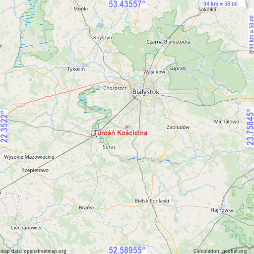
Turośń Kościelna GPS coordinates[2]
53° 0' 52.668" North, 23° 3' 19.152" East
| Map corner | latitude | longitude |
|---|---|---|
| Upper-left | 53.43557°, | 22.3522° |
| Center: | 53.01463°, | 23.05532° |
| Lower-right: | 52.58955°, | 23.75845° |
| Map W x H: | 94.1×94.1 km | = 58.5×58.5mi |
| max Lat: | 54.83135° ⇑16.2% North |
| Turośń Kościelna: | 53.01463° |
| min Lat: | ⇓83.8% South 49.21328° |
| min Long | Turośń Kości | max Long |
| 14.20249° | 23.05532° | 24.03723° |
| W 96.6%⇐ | ⇒3.4% E |
Elevation
Elevation of Turośń Kościelna is 129 m = 423 ft, and this is 62.4 m = 205 ft below average elevation for this country.
| Max E: |
974 m = 3196 ft | 66.4% |
| Avg. | 191.4 m = 628 ft | |
| Turośń Kościelna | 129 m = 423 ft | |
Min E: |
-3 m = -10 ft | 33.6% |
See also: Poland elevation on elevation.city.
Geographical zone
Turośń Kościelna is located in North temperate zone (between Tropic of Cancer and the Arctic Circle). Distance of this North polar circle is 1506.5 km =936.1 mi to North.| Distance of | km | miles | from Turośń Kościelna |
|---|---|---|---|
| North Pole | 4112.4 | 2555.3 | to North |
| Arctic Circle | 1506.5 | 936.1 | to North |
| Tropic Cancer | 3288.8 | 2043.6 | to South |
| Equator | 5894.7 | 3662.8 | to South |


Nearby cities:
15 places around Turośń Kościelna: (largest is in red/bold)
• Białystok
15.1 km =9.4 mi,  28°
28°
• Bielsk Podlaski
29.1 km =18.1 mi,  162°
162°
• Brańsk
33.4 km =20.8 mi,  205°
205°
• Choroszcz
15 km =9.3 mi,  342°
342°
• Dobrzyniewo Duże
20.8 km =12.9 mi,  351°
351°
• Narew
33.1 km =20.6 mi,  109°
109°
• Sokoły
23.9 km =14.9 mi,  264°
264°
• Supraśl
28.4 km =17.6 mi,  41°
41°
• Suraż
9.8 km =6.1 mi,  222°
222°
• Tykocin
28.3 km =17.6 mi,  318°
318°
• Wasilków
22.9 km =14.2 mi, 26°
• Wyszki
19.9 km =12.4 mi,  194°
194°
• Zabłudów
18.9 km =11.7 mi,  90°
90°
• Złotoria
20 km =12.4 mi, 335°
• Łapy
11.7 km =7.3 mi, 257°
Sources, notices
• [Note1] Compared only with cities in Poland existing in our database
• [Src1] Map data: © OpenStreetMap contributors (CC-BY-SA)
• [Src2] Other city data from geonames.org with taken over terms of usage.
• [Src3] Geographical zone / Annual Mean Temperature by Robert A. Rohde @ Wikipedia
