Bielsk Podlaski geodata
Bielsk Podlaski (Podlasie) is a seat of a third-order administrative division; located in Poland in Europe/Warsaw (GMT+2) time zone. With population of 26,493 people, there are 184 cities with bigger population in this country. Compared to other cities in Poland, 80.4% of cities are located further ↓South; 97.3% of cities are located further ←West and 63% of cities have higher elevation than Bielsk Podlaski. Note1


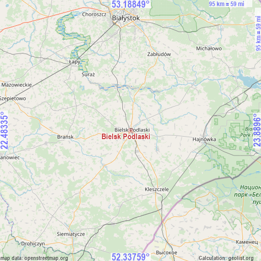
Bielsk Podlaski GPS coordinates[2]
52° 45' 54.432" North, 23° 11' 11.292" East
| Map corner | latitude | longitude |
|---|---|---|
| Upper-left | 53.18849°, | 22.48335° |
| Center: | 52.76512°, | 23.18647° |
| Lower-right: | 52.33759°, | 23.8896° |
| Map W x H: | 94.6×94.6 km | = 58.8×58.8mi |
| max Lat: | 54.83135° ⇑19.6% North |
| Bielsk Podlaski: | 52.76512° |
| min Lat: | ⇓80.4% South 49.21328° |
| min Long | Bielsk Podlaski | max Long |
| 14.20249° | 23.18647° | 24.03723° |
| W 97.3%⇐ | ⇒2.7% E |
Elevation
Elevation of Bielsk Podlaski is 139 m = 456 ft, and this is 52.4 m = 172 ft below average elevation for this country.
| Max E: |
974 m = 3196 ft | 63% |
| Avg. | 191.4 m = 628 ft | |
| Bielsk Podlaski | 139 m = 456 ft | |
Min E: |
-3 m = -10 ft | 37% |
See also: Poland elevation on elevation.city.
Geographical zone
Bielsk Podlaski is located in North temperate zone (between Tropic of Cancer and the Arctic Circle). Distance of this North polar circle is 1534.2 km =953.3 mi to North.| Distance of | km | miles | from Bielsk Podlaski |
|---|---|---|---|
| North Pole | 4140.1 | 2572.5 | to North |
| Arctic Circle | 1534.2 | 953.3 | to North |
| Tropic Cancer | 3261 | 2026.3 | to South |
| Equator | 5866.9 | 3645.5 | to South |


Nearby cities:
15 places around Bielsk Podlaski: (largest is in red/bold)
• Boćki
15.8 km =9.8 mi,  217°
217°
• Brańsk
23.6 km =14.7 mi,  264°
264°
• Czeremcha
29.7 km =18.5 mi,  158°
158°
• Czyże
15.9 km =9.9 mi,  87°
87°
• Dziadkowice
28.8 km =17.9 mi, 219°
• Hajnówka
26.7 km =16.6 mi,  95°
95°
• Kleszczele
23.3 km =14.5 mi, 156°
• Milejczyce
27.5 km =17.1 mi,  187°
187°
• Narew
27.9 km =17.3 mi,  53°
53°
• Orla
11.8 km =7.3 mi,  124°
124°
• Rudka
31.3 km =19.4 mi, 261°
• Suraż
25.6 km =15.9 mi,  322°
322°
• Turośń Kościelna
29.1 km =18.1 mi,  342°
342°
• Wyszki
16.2 km =10.1 mi,  301°
301°
• Zabłudów
29.5 km =18.3 mi,  20°
20°
Sources, notices
• [Note1] Compared only with cities in Poland existing in our database
• [Src1] Map data: © OpenStreetMap contributors (CC-BY-SA)
• [Src2] Other city data from geonames.org with taken over terms of usage.
• [Src3] Geographical zone / Annual Mean Temperature by Robert A. Rohde @ Wikipedia
