Narew geodata
Narew (Podlasie) is a populated place; located in Poland in Europe/Warsaw (GMT+2) time zone. With population of 1,400 people, there are 1959 cities with bigger population in this country. Compared to other cities in Poland, 82.6% of cities are located further ↓South; 98.9% of cities are located further ←West and 63% of cities have higher elevation than Narew. Note1


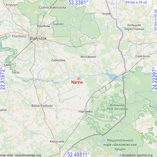
Narew GPS coordinates[2]
52° 54' 51.048" North, 23° 31' 11.424" East
| Map corner | latitude | longitude |
|---|---|---|
| Upper-left | 53.3361°, | 22.81672° |
| Center: | 52.91418°, | 23.51984° |
| Lower-right: | 52.48811°, | 24.22297° |
| Map W x H: | 94.3×94.3 km | = 58.6×58.6mi |
| max Lat: | 54.83135° ⇑17.4% North |
| Narew: | 52.91418° |
| min Lat: | ⇓82.6% South 49.21328° |
| min Long | Narew | max Long |
| 14.20249° | 23.51984° | 24.03723° |
| W 98.9%⇐ | ⇒1.1% E |
Elevation
Elevation of Narew is 139 m = 456 ft, and this is 52.4 m = 172 ft below average elevation for this country.
| Max E: |
974 m = 3196 ft | 63% |
| Avg. | 191.4 m = 628 ft | |
| Narew | 139 m = 456 ft | |
Min E: |
-3 m = -10 ft | 37% |
See also: Poland elevation on elevation.city.
Geographical zone
Narew is located in North temperate zone (between Tropic of Cancer and the Arctic Circle). Distance of this North polar circle is 1517.7 km =943.1 mi to North.| Distance of | km | miles | from Narew |
|---|---|---|---|
| North Pole | 4123.6 | 2562.3 | to North |
| Arctic Circle | 1517.7 | 943.1 | to North |
| Tropic Cancer | 3277.6 | 2036.6 | to South |
| Equator | 5883.5 | 3655.8 | to South |


Nearby cities:
15 places around Narew: (largest is in red/bold)
• Białowieża
33.3 km =20.7 mi,  135°
135°
• Białystok
34 km =21.1 mi,  315°
315°
• Bielsk Podlaski
27.9 km =17.3 mi,  233°
233°
• Czyże
17.2 km =10.7 mi,  202°
202°
• Grudki
22.4 km =13.9 mi,  26°
26°
• Hajnówka
19.4 km =12.1 mi,  167°
167°
• Michałowo
14.7 km =9.1 mi,  24°
24°
• Narewka
18.6 km =11.6 mi,  118°
118°
• Orla
26.4 km =16.4 mi,  208°
208°
• Supraśl
34.5 km =21.4 mi,  339°
339°
• Suraż
38 km =23.6 mi,  275°
275°
• Turośń Kościelna
33.1 km =20.6 mi,  289°
289°
• Wasilków
37.9 km =23.5 mi,  326°
326°
• Wyszki
37 km =23 mi,  257°
257°
• Zabłudów
16.5 km =10.3 mi,  312°
312°
Sources, notices
• [Note1] Compared only with cities in Poland existing in our database
• [Src1] Map data: © OpenStreetMap contributors (CC-BY-SA)
• [Src2] Other city data from geonames.org with taken over terms of usage.
• [Src3] Geographical zone / Annual Mean Temperature by Robert A. Rohde @ Wikipedia
