Supraśl geodata
Supraśl (Podlasie) is a seat of a third-order administrative division; located in Poland in Europe/Warsaw (GMT+2) time zone. With population of 4,526 people, there are 727 cities with bigger population in this country. Compared to other cities in Poland, 86.5% of cities are located further ↓South; 98% of cities are located further ←West and 65.2% of cities have higher elevation than Supraśl. Note1


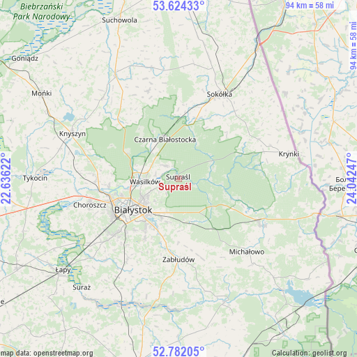
Supraśl GPS coordinates[2]
53° 12' 18.936" North, 23° 20' 21.624" East
| Map corner | latitude | longitude |
|---|---|---|
| Upper-left | 53.62433°, | 22.63622° |
| Center: | 53.20526°, | 23.33934° |
| Lower-right: | 52.78205°, | 24.04247° |
| Map W x H: | 93.7×93.7 km | = 58.2×58.2mi |
| max Lat: | 54.83135° ⇑13.5% North |
| Supraśl: | 53.20526° |
| min Lat: | ⇓86.5% South 49.21328° |
| min Long | Supraśl | max Long |
| 14.20249° | 23.33934° | 24.03723° |
| W 98%⇐ | ⇒2% E |
Elevation
Elevation of Supraśl is 132 m = 433 ft, and this is 59.4 m = 195 ft below average elevation for this country.
| Max E: |
974 m = 3196 ft | 65.2% |
| Avg. | 191.4 m = 628 ft | |
| Supraśl | 132 m = 433 ft | |
Min E: |
-3 m = -10 ft | 34.8% |
See also: Poland elevation on elevation.city.
Geographical zone
Supraśl is located in North temperate zone (between Tropic of Cancer and the Arctic Circle). Distance of this North polar circle is 1485.3 km =922.9 mi to North.| Distance of | km | miles | from Supraśl |
|---|---|---|---|
| North Pole | 4091.2 | 2542.2 | to North |
| Arctic Circle | 1485.3 | 922.9 | to North |
| Tropic Cancer | 3310 | 2056.7 | to South |
| Equator | 5915.9 | 3676 | to South |


Nearby cities:
15 places around Supraśl: (largest is in red/bold)
• Białystok
14.1 km =8.8 mi,  235°
235°
• Choroszcz
24.4 km =15.2 mi,  253°
253°
• Czarna Białostocka
11.7 km =7.3 mi,  340°
340°
• Dobrzyniewo Duże
21.9 km =13.6 mi,  268°
268°
• Grudki
25.1 km =15.6 mi,  119°
119°
• Janów
30 km =18.6 mi,  346°
346°
• Jasionówka
29.1 km =18.1 mi,  316°
316°
• Krynki
29.6 km =18.4 mi,  77°
77°
• Michałowo
26.2 km =16.3 mi,  136°
136°
• Sokółka
24.9 km =15.5 mi,  25°
25°
• Szudziałowo
23.4 km =14.5 mi,  63°
63°
• Turośń Kościelna
28.4 km =17.6 mi,  221°
221°
• Wasilków
8.8 km =5.5 mi, 265°
• Zabłudów
21.2 km =13.2 mi,  180°
180°
• Złotoria
27.3 km =17 mi,  263°
263°
Sources, notices
• [Note1] Compared only with cities in Poland existing in our database
• [Src1] Map data: © OpenStreetMap contributors (CC-BY-SA)
• [Src2] Other city data from geonames.org with taken over terms of usage.
• [Src3] Geographical zone / Annual Mean Temperature by Robert A. Rohde @ Wikipedia
