Suraż geodata
Suraż (Podlasie) is a seat of a third-order administrative division; located in Poland in Europe/Warsaw (GMT+2) time zone. With population of 993 people, there are 2506 cities with bigger population in this country. Compared to other cities in Poland, 83% of cities are located further ↓South; 95.8% of cities are located further ←West and 68.9% of cities have higher elevation than Suraż. Note1


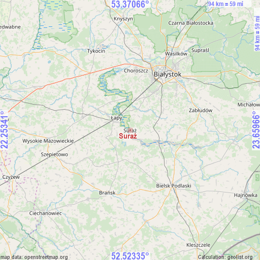
Suraż GPS coordinates[2]
52° 56' 56.688" North, 22° 57' 23.508" East
| Map corner | latitude | longitude |
|---|---|---|
| Upper-left | 53.37066°, | 22.25341° |
| Center: | 52.94908°, | 22.95653° |
| Lower-right: | 52.52335°, | 23.65966° |
| Map W x H: | 94.2×94.2 km | = 58.5×58.5mi |
| max Lat: | 54.83135° ⇑17% North |
| Suraż: | 52.94908° |
| min Lat: | ⇓83% South 49.21328° |
| min Long | Suraż | max Long |
| 14.20249° | 22.95653° | 24.03723° |
| W 95.8%⇐ | ⇒4.2% E |
Elevation
Elevation of Suraż is 123 m = 404 ft, and this is 68.4 m = 224 ft below average elevation for this country.
| Max E: |
974 m = 3196 ft | 68.9% |
| Avg. | 191.4 m = 628 ft | |
| Suraż | 123 m = 404 ft | |
Min E: |
-3 m = -10 ft | 31.1% |
See also: Poland elevation on elevation.city.
Geographical zone
Suraż is located in North temperate zone (between Tropic of Cancer and the Arctic Circle). Distance of this North polar circle is 1513.8 km =940.6 mi to North.| Distance of | km | miles | from Suraż |
|---|---|---|---|
| North Pole | 4119.7 | 2559.9 | to North |
| Arctic Circle | 1513.8 | 940.6 | to North |
| Tropic Cancer | 3281.5 | 2039 | to South |
| Equator | 5887.4 | 3658.3 | to South |


Nearby cities:
15 places around Suraż: (largest is in red/bold)
• Białystok
24.8 km =15.4 mi,  34°
34°
• Bielsk Podlaski
25.6 km =15.9 mi,  142°
142°
• Brańsk
24.1 km =15 mi,  199°
199°
• Choroszcz
21.7 km =13.5 mi,  5°
5°
• Dobrzyniewo Duże
28.2 km =17.5 mi, 7°
• Rudka
29.4 km =18.3 mi,  211°
211°
• Sokoły
17.8 km =11.1 mi,  285°
285°
• Szepietowo
29 km =18 mi,  252°
252°
• Turośń Kościelna
9.8 km =6.1 mi,  42°
42°
• Tykocin
31 km =19.3 mi,  336°
336°
• Wysokie Mazowieckie
29.7 km =18.5 mi,  263°
263°
• Wyszki
12.1 km =7.5 mi,  172°
172°
• Zabłudów
26.6 km =16.5 mi,  74°
74°
• Złotoria
25.5 km =15.8 mi,  356°
356°
• Łapy
6.7 km =4.2 mi,  313°
313°
Sources, notices
• [Note1] Compared only with cities in Poland existing in our database
• [Src1] Map data: © OpenStreetMap contributors (CC-BY-SA)
• [Src2] Other city data from geonames.org with taken over terms of usage.
• [Src3] Geographical zone / Annual Mean Temperature by Robert A. Rohde @ Wikipedia
