Goniadz geodata
Goniadz (Podlasie) is a populated place; located in Poland in Europe/Warsaw (GMT+2) time zone. With population of 1,954 people, there are 1517 cities with bigger population in this country. Compared to other cities in Poland, 89.4% of cities are located further ↓South; 94.1% of cities are located further ←West and 64.7% of cities have higher elevation than Goniadz. Note1


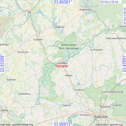
Goniadz GPS coordinates[2]
53° 29' 22.308" North, 22° 44' 8.808" East
| Map corner | latitude | longitude |
|---|---|---|
| Upper-left | 53.90581°, | 22.03266° |
| Center: | 53.48953°, | 22.73578° |
| Lower-right: | 53.06913°, | 23.43891° |
| Map W x H: | 93×93 km | = 57.8×57.8mi |
| max Lat: | 54.83135° ⇑10.6% North |
| Goniadz: | 53.48953° |
| min Lat: | ⇓89.4% South 49.21328° |
| min Long | Goniadz | max Long |
| 14.20249° | 22.73578° | 24.03723° |
| W 94.1%⇐ | ⇒5.9% E |
Elevation
Elevation of Goniadz is 134 m = 440 ft, and this is 57.4 m = 188 ft below average elevation for this country.
| Max E: |
974 m = 3196 ft | 64.7% |
| Avg. | 191.4 m = 628 ft | |
| Goniadz | 134 m = 440 ft | |
Min E: |
-3 m = -10 ft | 35.3% |
See also: Poland elevation on elevation.city.
Geographical zone
Goniadz is located in North temperate zone (between Tropic of Cancer and the Arctic Circle). Distance of this North polar circle is 1453.7 km =903.3 mi to North.| Distance of | km | miles | from Goniadz |
|---|---|---|---|
| North Pole | 4059.6 | 2522.5 | to North |
| Arctic Circle | 1453.7 | 903.3 | to North |
| Tropic Cancer | 3341.6 | 2076.4 | to South |
| Equator | 5947.5 | 3695.6 | to South |


Nearby cities:
15 places around Goniadz: (largest is in red/bold)
• Bargłów Kościelny
32.1 km =19.9 mi,  10°
10°
• Grajewo
25.5 km =15.8 mi,  313°
313°
• Jasionówka
22.6 km =14 mi,  117°
117°
• Jaświły
14.2 km =8.8 mi,  94°
94°
• Knyszyn
23 km =14.3 mi,  148°
148°
• Korycin
24 km =14.9 mi,  101°
101°
• Mońki
10.3 km =6.4 mi,  156°
156°
• Prostki
30.7 km =19.1 mi,  319°
319°
• Radziłów
23.3 km =14.5 mi,  247°
247°
• Rajgród
26.9 km =16.7 mi,  355°
355°
• Suchowola
26.3 km =16.3 mi,  68°
68°
• Szczuczyn
30.9 km =19.2 mi,  285°
285°
• Trzcianne
16.3 km =10.1 mi,  192°
192°
• Tykocin
31.7 km =19.7 mi,  175°
175°
• Wąsosz
27.8 km =17.3 mi,  277°
277°
Sources, notices
• [Note1] Compared only with cities in Poland existing in our database
• [Src1] Map data: © OpenStreetMap contributors (CC-BY-SA)
• [Src2] Other city data from geonames.org with taken over terms of usage.
• [Src3] Geographical zone / Annual Mean Temperature by Robert A. Rohde @ Wikipedia
