Jedwabne geodata
Jedwabne (Podlasie) is a seat of a third-order administrative division; located in Poland in Europe/Warsaw (GMT+2) time zone. With population of 2,204 people, there are 1360 cities with bigger population in this country. Compared to other cities in Poland, 87.3% of cities are located further ↓South; 88.8% of cities are located further ←West and 53.3% of cities have higher elevation than Jedwabne. Note1


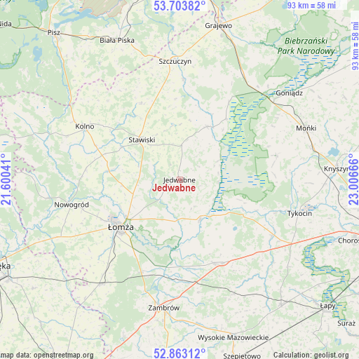
Jedwabne GPS coordinates[2]
53° 17' 7.944" North, 22° 18' 12.708" East
| Map corner | latitude | longitude |
|---|---|---|
| Upper-left | 53.70382°, | 21.60041° |
| Center: | 53.28554°, | 22.30353° |
| Lower-right: | 52.86312°, | 23.00666° |
| Map W x H: | 93.5×93.5 km | = 58.1×58.1mi |
| max Lat: | 54.83135° ⇑12.7% North |
| Jedwabne: | 53.28554° |
| min Lat: | ⇓87.3% South 49.21328° |
| min Long | Jedwabne | max Long |
| 14.20249° | 22.30353° | 24.03723° |
| W 88.8%⇐ | ⇒11.2% E |
Elevation
Elevation of Jedwabne is 163 m = 535 ft, and this is 28.4 m = 93 ft below average elevation for this country.
| Max E: |
974 m = 3196 ft | 53.3% |
| Avg. | 191.4 m = 628 ft | |
| Jedwabne | 163 m = 535 ft | |
Min E: |
-3 m = -10 ft | 46.7% |
See also: Poland elevation on elevation.city.
Geographical zone
Jedwabne is located in North temperate zone (between Tropic of Cancer and the Arctic Circle). Distance of this North polar circle is 1476.4 km =917.4 mi to North.| Distance of | km | miles | from Jedwabne |
|---|---|---|---|
| North Pole | 4082.3 | 2536.6 | to North |
| Arctic Circle | 1476.4 | 917.4 | to North |
| Tropic Cancer | 3318.9 | 2062.3 | to South |
| Equator | 5924.8 | 3681.5 | to South |


Nearby cities:
15 places around Jedwabne: (largest is in red/bold)
• Czarnocin
17 km =10.6 mi,  242°
242°
• Gać
23.2 km =14.4 mi,  189°
189°
• Grabowo
22.4 km =13.9 mi,  333°
333°
• Janowo
26.7 km =16.6 mi,  286°
286°
• Kolno
28.5 km =17.7 mi,  299°
299°
• Mały Płock
18.4 km =11.4 mi,  276°
276°
• Piątnica
17 km =10.6 mi,  234°
234°
• Radziłów
15.5 km =9.6 mi,  27°
27°
• Rutki
22.4 km =13.9 mi,  157°
157°
• Rutki-Kossaki
23.6 km =14.7 mi, 157°
• Stawiski
14.4 km =8.9 mi,  316°
316°
• Trzcianne
26.1 km =16.2 mi,  75°
75°
• Wizna
11.3 km =7 mi,  152°
152°
• Wąsosz
26.3 km =16.3 mi,  2°
2°
• Łomża
20.2 km =12.6 mi, 233°
Sources, notices
• [Note1] Compared only with cities in Poland existing in our database
• [Src1] Map data: © OpenStreetMap contributors (CC-BY-SA)
• [Src2] Other city data from geonames.org with taken over terms of usage.
• [Src3] Geographical zone / Annual Mean Temperature by Robert A. Rohde @ Wikipedia
