Tereszpol geodata
Tereszpol (Lublin) is a seat of a third-order administrative division; located in Poland in Europe/Warsaw (GMT+2) time zone. With population of 1,157 people, there are 2251 cities with bigger population in this country. Compared to other cities in Poland, 65.6% of cities are located further ↑North; 95% of cities are located further ←West and 77.2% of cities have lower elevation than Tereszpol. Note1


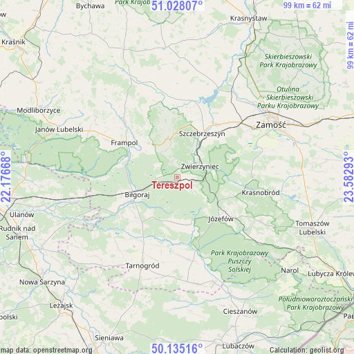
Tereszpol GPS coordinates[2]
50° 35' 1.428" North, 22° 52' 47.28" East
| Map corner | latitude | longitude |
|---|---|---|
| Upper-left | 51.02807°, | 22.17668° |
| Center: | 50.58373°, | 22.8798° |
| Lower-right: | 50.13516°, | 23.58293° |
| Map W x H: | 99.3×99.3 km | = 61.7×61.7mi |
| max Lat: | 54.83135° ⇑65.6% North |
| Tereszpol: | 50.58373° |
| min Lat: | ⇓34.4% South 49.21328° |
| min Long | Tereszpol | max Long |
| 14.20249° | 22.8798° | 24.03723° |
| W 95%⇐ | ⇒5% E |
Elevation
Elevation of Tereszpol is 255 m = 837 ft, and this is 63.6 m = 209 ft above average elevation for this country.
| Max E: |
974 m = 3196 ft | 22.8% |
| Tereszpol | 255 m 837 ft | |
| Avg. | 191.4 m = 628 ft | |
Min E: |
-3 m = -10 ft | 77.2% |
See also: Poland elevation on elevation.city.
Geographical zone
Tereszpol is located in North temperate zone (between Tropic of Cancer and the Arctic Circle). Distance of this North polar circle is 1776.8 km =1104.1 mi to North.| Distance of | km | miles | from Tereszpol |
|---|---|---|---|
| North Pole | 4382.7 | 2723.3 | to North |
| Arctic Circle | 1776.8 | 1104.1 | to North |
| Tropic Cancer | 3018.5 | 1875.6 | to South |
| Equator | 5624.4 | 3494.8 | to South |


Nearby cities:
15 places around Tereszpol: (largest is in red/bold)
• Aleksandrów
13.1 km =8.1 mi,  176°
176°
• Biłgoraj
12.1 km =7.5 mi,  246°
246°
• Frampol
17.7 km =11 mi,  303°
303°
• Goraj
21.5 km =13.4 mi,  315°
315°
• Józefów
16.8 km =10.4 mi,  132°
132°
• Kawęczyn
11.2 km =7 mi,  24°
24°
• Krasnobród
23.9 km =14.9 mi,  100°
100°
• Księżpol
20.6 km =12.8 mi,  209°
209°
• Michałów
19.8 km =12.3 mi,  30°
30°
• Radecznica
19 km =11.8 mi,  349°
349°
• Stanisławów
20.1 km =12.5 mi,  114°
114°
• Sułów
21.5 km =13.4 mi,  14°
14°
• Szczebrzeszyn
14.2 km =8.8 mi, 29°
• Zwierzyniec
7.5 km =4.7 mi,  63°
63°
• Łukowa
23.7 km =14.7 mi,  169°
169°
Sources, notices
• [Note1] Compared only with cities in Poland existing in our database
• [Src1] Map data: © OpenStreetMap contributors (CC-BY-SA)
• [Src2] Other city data from geonames.org with taken over terms of usage.
• [Src3] Geographical zone / Annual Mean Temperature by Robert A. Rohde @ Wikipedia
