Sułów geodata
Sułów (Lublin) is a seat of a third-order administrative division; located in Poland in Europe/Warsaw (GMT+2) time zone. With population of 460 people, there are 3556 cities with bigger population in this country. Compared to other cities in Poland, 60.9% of cities are located further ↑North; 95.7% of cities are located further ←West and 61% of cities have lower elevation than Sułów. Note1


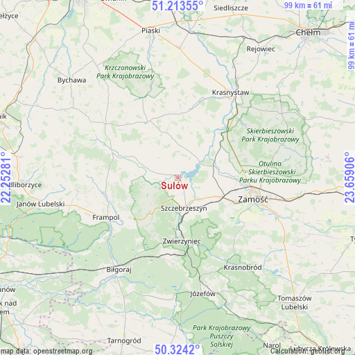
Sułów GPS coordinates[2]
50° 46' 15.564" North, 22° 57' 21.348" East
| Map corner | latitude | longitude |
|---|---|---|
| Upper-left | 51.21355°, | 22.25281° |
| Center: | 50.77099°, | 22.95593° |
| Lower-right: | 50.3242°, | 23.65906° |
| Map W x H: | 98.9×98.9 km | = 61.5×61.5mi |
| max Lat: | 54.83135° ⇑60.9% North |
| Sułów: | 50.77099° |
| min Lat: | ⇓39.1% South 49.21328° |
| min Long | Sułów | max Long |
| 14.20249° | 22.95593° | 24.03723° |
| W 95.7%⇐ | ⇒4.3% E |
Elevation
Elevation of Sułów is 203 m = 666 ft, and this is 11.6 m = 38 ft above average elevation for this country.
| Max E: |
974 m = 3196 ft | 39% |
| Sułów | 203 m 666 ft | |
| Avg. | 191.4 m = 628 ft | |
Min E: |
-3 m = -10 ft | 61% |
See also: Poland elevation on elevation.city.
Geographical zone
Sułów is located in North temperate zone (between Tropic of Cancer and the Arctic Circle). Distance of this North polar circle is 1756 km =1091.1 mi to North.| Distance of | km | miles | from Sułów |
|---|---|---|---|
| North Pole | 4361.9 | 2710.4 | to North |
| Arctic Circle | 1756 | 1091.1 | to North |
| Tropic Cancer | 3039.3 | 1888.5 | to South |
| Equator | 5645.2 | 3507.8 | to South |


Nearby cities:
15 places around Sułów: (largest is in red/bold)
• Gorzków
20.1 km =12.5 mi,  11°
11°
• Izbica
18.9 km =11.7 mi,  46°
46°
• Kawęczyn
10.7 km =6.6 mi,  183°
183°
• Krasne
18.4 km =11.4 mi,  55°
55°
• Michałów
6 km =3.7 mi,  128°
128°
• Nielisz
7 km =4.3 mi, 62°
• Radecznica
9.1 km =5.7 mi,  256°
256°
• Rudnik
12.2 km =7.6 mi, 5°
• Stary Zamość
16.1 km =10 mi,  70°
70°
• Szczebrzeszyn
8.6 km =5.3 mi,  168°
168°
• Turobin
16.1 km =10 mi,  291°
291°
• Wysokie
18.8 km =11.7 mi,  95°
95°
• Zwierzyniec
17.5 km =10.9 mi, 175°
• Żabno
15.7 km =9.8 mi,  305°
305°
• Żółkiewka
17.6 km =10.9 mi,  331°
331°
Sources, notices
• [Note1] Compared only with cities in Poland existing in our database
• [Src1] Map data: © OpenStreetMap contributors (CC-BY-SA)
• [Src2] Other city data from geonames.org with taken over terms of usage.
• [Src3] Geographical zone / Annual Mean Temperature by Robert A. Rohde @ Wikipedia
