Szczebrzeszyn geodata
Szczebrzeszyn (Lublin) is a seat of a third-order administrative division; located in Poland in Europe/Warsaw (GMT+2) time zone. With population of 5,255 people, there are 661 cities with bigger population in this country. Compared to other cities in Poland, 62.8% of cities are located further ↑North; 96% of cities are located further ←West and 64.8% of cities have lower elevation than Szczebrzeszyn. Note1


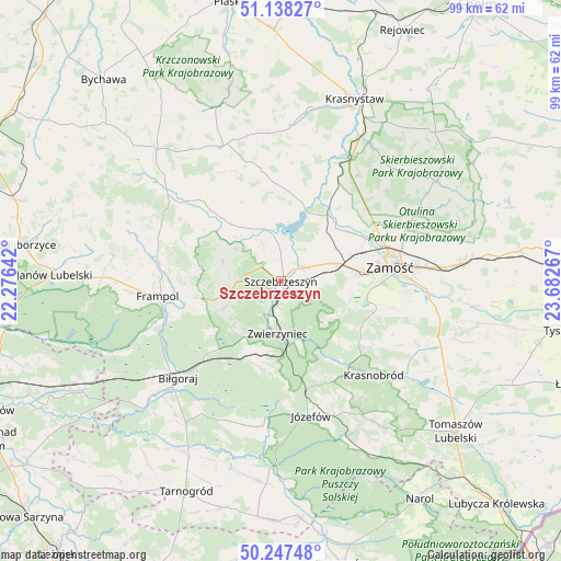
Szczebrzeszyn GPS coordinates[2]
50° 41' 41.964" North, 22° 58' 46.344" East
| Map corner | latitude | longitude |
|---|---|---|
| Upper-left | 51.13827°, | 22.27642° |
| Center: | 50.69499°, | 22.97954° |
| Lower-right: | 50.24748°, | 23.68267° |
| Map W x H: | 99×99 km | = 61.5×61.5mi |
| max Lat: | 54.83135° ⇑62.8% North |
| Szczebrzeszyn: | 50.69499° |
| min Lat: | ⇓37.2% South 49.21328° |
| min Long | Szczebrzeszyn | max Long |
| 14.20249° | 22.97954° | 24.03723° |
| W 96%⇐ | ⇒4% E |
Elevation
Elevation of Szczebrzeszyn is 214 m = 702 ft, and this is 22.6 m = 74 ft above average elevation for this country.
| Max E: |
974 m = 3196 ft | 35.2% |
| Szczebrzeszyn | 214 m 702 ft | |
| Avg. | 191.4 m = 628 ft | |
Min E: |
-3 m = -10 ft | 64.8% |
See also: Poland elevation on elevation.city.
Geographical zone
Szczebrzeszyn is located in North temperate zone (between Tropic of Cancer and the Arctic Circle). Distance of this North polar circle is 1764.4 km =1096.3 mi to North.| Distance of | km | miles | from Szczebrzeszyn |
|---|---|---|---|
| North Pole | 4370.3 | 2715.6 | to North |
| Arctic Circle | 1764.4 | 1096.3 | to North |
| Tropic Cancer | 3030.8 | 1883.3 | to South |
| Equator | 5636.8 | 3502.5 | to South |


Nearby cities:
15 places around Szczebrzeszyn: (largest is in red/bold)
• Frampol
21.9 km =13.6 mi,  263°
263°
• Goraj
22.2 km =13.8 mi,  277°
277°
• Kawęczyn
3.3 km =2.1 mi,  226°
226°
• Michałów
5.6 km =3.5 mi,  33°
33°
• Nielisz
12.6 km =7.8 mi,  21°
21°
• Radecznica
12.3 km =7.6 mi,  300°
300°
• Rudnik
20.6 km =12.8 mi,  358°
358°
• Stary Zamość
19.4 km =12.1 mi,  44°
44°
• Sułów
8.6 km =5.3 mi,  348°
348°
• Tereszpol
14.2 km =8.8 mi,  209°
209°
• Turobin
22 km =13.7 mi,  310°
310°
• Wysokie
18.3 km =11.4 mi,  69°
69°
• Zamość
19.4 km =12.1 mi,  80°
80°
• Zwierzyniec
9 km =5.6 mi,  181°
181°
• Żabno
22.8 km =14.2 mi,  320°
320°
Sources, notices
• [Note1] Compared only with cities in Poland existing in our database
• [Src1] Map data: © OpenStreetMap contributors (CC-BY-SA)
• [Src2] Other city data from geonames.org with taken over terms of usage.
• [Src3] Geographical zone / Annual Mean Temperature by Robert A. Rohde @ Wikipedia
