Biłgoraj geodata
Biłgoraj (Lublin) is a seat of a second-order administrative division; located in Poland in Europe/Warsaw (GMT+2) time zone. With population of 26,987 people, there are 181 cities with bigger population in this country. Compared to other cities in Poland, 66.4% of cities are located further ↑North; 94% of cities are located further ←West and 60.6% of cities have lower elevation than Biłgoraj. Note1


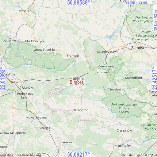
Biłgoraj GPS coordinates[2]
50° 32' 28.104" North, 22° 43' 19.344" East
| Map corner | latitude | longitude |
|---|---|---|
| Upper-left | 50.98588°, | 22.01892° |
| Center: | 50.54114°, | 22.72204° |
| Lower-right: | 50.09217°, | 23.42517° |
| Map W x H: | 99.4×99.4 km | = 61.8×61.8mi |
| max Lat: | 54.83135° ⇑66.4% North |
| Biłgoraj: | 50.54114° |
| min Lat: | ⇓33.6% South 49.21328° |
| min Long | Biłgoraj | max Long |
| 14.20249° | 22.72204° | 24.03723° |
| W 94%⇐ | ⇒6% E |
Elevation
Elevation of Biłgoraj is 202 m = 663 ft, and this is 10.6 m = 35 ft above average elevation for this country.
| Max E: |
974 m = 3196 ft | 39.4% |
| Biłgoraj | 202 m 663 ft | |
| Avg. | 191.4 m = 628 ft | |
Min E: |
-3 m = -10 ft | 60.6% |
See also: Poland elevation on elevation.city.
Geographical zone
Biłgoraj is located in North temperate zone (between Tropic of Cancer and the Arctic Circle). Distance of this North polar circle is 1781.5 km =1107 mi to North.| Distance of | km | miles | from Biłgoraj |
|---|---|---|---|
| North Pole | 4387.4 | 2726.2 | to North |
| Arctic Circle | 1781.5 | 1107 | to North |
| Tropic Cancer | 3013.7 | 1872.6 | to South |
| Equator | 5619.6 | 3491.9 | to South |


Nearby cities:
15 places around Biłgoraj: (largest is in red/bold)
• Aleksandrów
14.6 km =9.1 mi,  124°
124°
• Biszcza
16.3 km =10.1 mi,  198°
198°
• Dzwola
20.4 km =12.7 mi,  327°
327°
• Frampol
15 km =9.3 mi,  345°
345°
• Goraj
20.5 km =12.7 mi, 348°
• Harasiuki
19.1 km =11.9 mi,  247°
247°
• Józefów
24.4 km =15.2 mi,  105°
105°
• Kawęczyn
21.7 km =13.5 mi,  46°
46°
• Księżpol
13.1 km =8.1 mi,  175°
175°
• Potok Górny
20.8 km =12.9 mi,  213°
213°
• Radecznica
24.6 km =15.3 mi,  17°
17°
• Tarnogród
20.1 km =12.5 mi, 176°
• Tereszpol
12.1 km =7.5 mi,  66°
66°
• Zwierzyniec
19.6 km =12.2 mi, 65°
• Łukowa
24.3 km =15.1 mi,  139°
139°
Sources, notices
• [Note1] Compared only with cities in Poland existing in our database
• [Src1] Map data: © OpenStreetMap contributors (CC-BY-SA)
• [Src2] Other city data from geonames.org with taken over terms of usage.
• [Src3] Geographical zone / Annual Mean Temperature by Robert A. Rohde @ Wikipedia
