Kawęczyn geodata
Kawęczyn (Lublin) is a populated place; located in Poland in Europe/Warsaw (GMT+2) time zone. With population of 565 people, there are 3369 cities with bigger population in this country. Compared to other cities in Poland, 63.2% of cities are located further ↑North; 95.7% of cities are located further ←West and 64.8% of cities have lower elevation than Kawęczyn. Note1


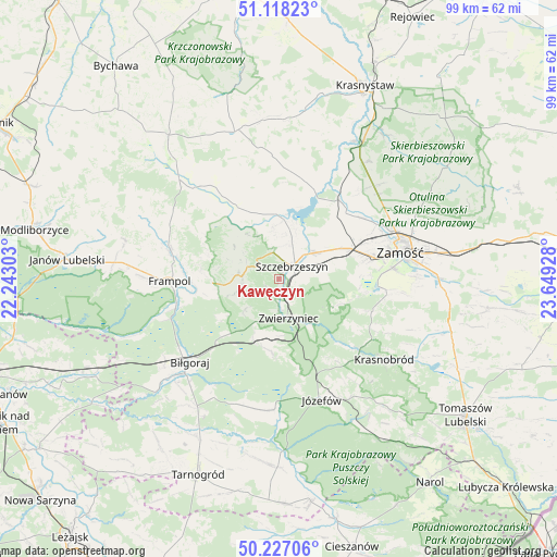
Kawęczyn GPS coordinates[2]
50° 40' 29.136" North, 22° 56' 46.14" East
| Map corner | latitude | longitude |
|---|---|---|
| Upper-left | 51.11823°, | 22.24303° |
| Center: | 50.67476°, | 22.94615° |
| Lower-right: | 50.22706°, | 23.64928° |
| Map W x H: | 99.1×99.1 km | = 61.6×61.6mi |
| max Lat: | 54.83135° ⇑63.2% North |
| Kawęczyn: | 50.67476° |
| min Lat: | ⇓36.8% South 49.21328° |
| min Long | Kawęczyn | max Long |
| 14.20249° | 22.94615° | 24.03723° |
| W 95.7%⇐ | ⇒4.3% E |
Elevation
Elevation of Kawęczyn is 214 m = 702 ft, and this is 22.6 m = 74 ft above average elevation for this country.
| Max E: |
974 m = 3196 ft | 35.2% |
| Kawęczyn | 214 m 702 ft | |
| Avg. | 191.4 m = 628 ft | |
Min E: |
-3 m = -10 ft | 64.8% |
See also: Poland elevation on elevation.city.
Geographical zone
Kawęczyn is located in North temperate zone (between Tropic of Cancer and the Arctic Circle). Distance of this North polar circle is 1766.7 km =1097.8 mi to North.| Distance of | km | miles | from Kawęczyn |
|---|---|---|---|
| North Pole | 4372.6 | 2717 | to North |
| Arctic Circle | 1766.7 | 1097.8 | to North |
| Tropic Cancer | 3028.6 | 1881.9 | to South |
| Equator | 5634.5 | 3501.1 | to South |


Nearby cities:
15 places around Kawęczyn: (largest is in red/bold)
• Biłgoraj
21.7 km =13.5 mi,  226°
226°
• Frampol
19.4 km =12.1 mi,  268°
268°
• Goraj
20.4 km =12.7 mi,  284°
284°
• Józefów
22.8 km =14.2 mi,  160°
160°
• Michałów
8.8 km =5.5 mi,  37°
37°
• Nielisz
15.6 km =9.7 mi,  26°
26°
• Radecznica
11.8 km =7.3 mi,  316°
316°
• Stary Zamość
22.6 km =14 mi, 44°
• Sułów
10.7 km =6.6 mi,  3°
3°
• Szczebrzeszyn
3.3 km =2.1 mi,  46°
46°
• Tereszpol
11.2 km =7 mi,  204°
204°
• Turobin
21.9 km =13.6 mi, 319°
• Wysokie
21.3 km =13.2 mi,  65°
65°
• Zamość
22.2 km =13.8 mi,  75°
75°
• Zwierzyniec
7.1 km =4.4 mi, 163°
Sources, notices
• [Note1] Compared only with cities in Poland existing in our database
• [Src1] Map data: © OpenStreetMap contributors (CC-BY-SA)
• [Src2] Other city data from geonames.org with taken over terms of usage.
• [Src3] Geographical zone / Annual Mean Temperature by Robert A. Rohde @ Wikipedia
