Szczucin geodata
Szczucin (Lesser Poland) is a seat of a third-order administrative division; located in Poland in Europe/Warsaw (GMT+2) time zone. With population of 4,166 people, there are 785 cities with bigger population in this country. Compared to other cities in Poland, 71.9% of cities are located further ↑North; 74% of cities are located further ←West and 52.5% of cities have higher elevation than Szczucin. Note1


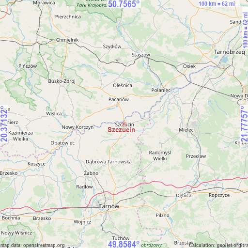
Szczucin GPS coordinates[2]
50° 18' 34.452" North, 21° 4' 27.984" East
| Map corner | latitude | longitude |
|---|---|---|
| Upper-left | 50.7565°, | 20.37132° |
| Center: | 50.30957°, | 21.07444° |
| Lower-right: | 49.8584°, | 21.77757° |
| Map W x H: | 99.9×99.9 km | = 62.1×62.1mi |
| max Lat: | 54.83135° ⇑71.9% North |
| Szczucin: | 50.30957° |
| min Lat: | ⇓28.1% South 49.21328° |
| min Long | Szczucin | max Long |
| 14.20249° | 21.07444° | 24.03723° |
| W 74%⇐ | ⇒26% E |
Elevation
Elevation of Szczucin is 165 m = 541 ft, and this is 26.4 m = 87 ft below average elevation for this country.
| Max E: |
974 m = 3196 ft | 52.5% |
| Avg. | 191.4 m = 628 ft | |
| Szczucin | 165 m = 541 ft | |
Min E: |
-3 m = -10 ft | 47.5% |
See also: Poland elevation on elevation.city.
Geographical zone
Szczucin is located in North temperate zone (between Tropic of Cancer and the Arctic Circle). Distance of this North polar circle is 1807.3 km =1123 mi to North.| Distance of | km | miles | from Szczucin |
|---|---|---|---|
| North Pole | 4413.2 | 2742.2 | to North |
| Arctic Circle | 1807.3 | 1123 | to North |
| Tropic Cancer | 2988 | 1856.7 | to South |
| Equator | 5593.9 | 3475.9 | to South |


Nearby cities:
15 places around Szczucin: (largest is in red/bold)
• Bolesław
13 km =8.1 mi,  251°
251°
• Dąbrowa Tarnowska
16.3 km =10.1 mi,  202°
202°
• Gruszów Wielki
13.5 km =8.4 mi,  193°
193°
• Mędrzechów
9.5 km =5.9 mi, 251°
• Olesno
16 km =9.9 mi,  221°
221°
• Oleśnica
16 km =9.9 mi,  357°
357°
• Pacanów
10.4 km =6.5 mi,  346°
346°
• Radgoszcz
11.9 km =7.4 mi,  166°
166°
• Smęgorzów
10.3 km =6.4 mi,  208°
208°
• Solec-Zdrój
14.5 km =9 mi,  295°
295°
• Swarzów
15.3 km =9.5 mi, 213°
• Słupia
8.5 km =5.3 mi,  343°
343°
• Słupiec
8.7 km =5.4 mi,  76°
76°
• Wadowice Górne
17 km =10.6 mi,  107°
107°
• Łubnice
12.6 km =7.8 mi,  25°
25°
Sources, notices
• [Note1] Compared only with cities in Poland existing in our database
• [Src1] Map data: © OpenStreetMap contributors (CC-BY-SA)
• [Src2] Other city data from geonames.org with taken over terms of usage.
• [Src3] Geographical zone / Annual Mean Temperature by Robert A. Rohde @ Wikipedia
