Szczawnica geodata
Szczawnica (Lesser Poland) is a populated place; located in Poland in Europe/Warsaw (GMT+2) time zone. With population of 6,032 people, there are 602 cities with bigger population in this country. Compared to other cities in Poland, 99.5% of cities are located further ↑North; 64.9% of cities are located further ←West and 96.8% of cities have lower elevation than Szczawnica. Note1


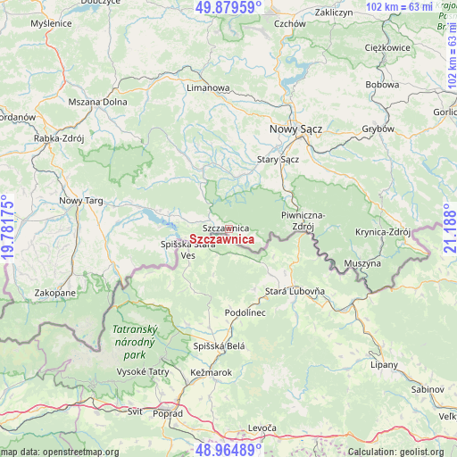
Szczawnica GPS coordinates[2]
49° 25' 27.732" North, 20° 29' 5.532" East
| Map corner | latitude | longitude |
|---|---|---|
| Upper-left | 49.87959°, | 19.78175° |
| Center: | 49.42437°, | 20.48487° |
| Lower-right: | 48.96489°, | 21.188° |
| Map W x H: | 101.7×101.7 km | = 63.2×63.2mi |
| max Lat: | 54.83135° ⇑99.5% North |
| Szczawnica: | 49.42437° |
| min Lat: | ⇓0.5% South 49.21328° |
| min Long | Szczawnica | max Long |
| 14.20249° | 20.48487° | 24.03723° |
| W 64.9%⇐ | ⇒35.1% E |
Elevation
Elevation of Szczawnica is 464 m = 1522 ft, and this is 272.6 m = 894 ft above average elevation for this country.
| Max E: |
974 m = 3196 ft | 3.2% |
| Szczawnica | 464 m 1522 ft | |
| Avg. | 191.4 m = 628 ft | |
Min E: |
-3 m = -10 ft | 96.8% |
See also: Poland elevation on elevation.city.
Geographical zone
Szczawnica is located in North temperate zone (between Tropic of Cancer and the Arctic Circle). Distance of this North polar circle is 1905.7 km =1184.1 mi to North.| Distance of | km | miles | from Szczawnica |
|---|---|---|---|
| North Pole | 4511.6 | 2803.4 | to North |
| Arctic Circle | 1905.7 | 1184.1 | to North |
| Tropic Cancer | 2889.6 | 1795.5 | to South |
| Equator | 5495.5 | 3414.7 | to South |


Nearby cities:
15 places around Szczawnica: (largest is in red/bold)
• Kluszkowce
13.6 km =8.5 mi,  282°
282°
• Krościenko nad Dunajcem
4.6 km =2.9 mi,  293°
293°
• Krośnica
10.8 km =6.7 mi, 283°
• Maniowy
16.4 km =10.2 mi, 283°
• Naszacowice
16.3 km =10.1 mi,  18°
18°
• Niedzica
13.3 km =8.3 mi,  263°
263°
• Ochotnica Dolna
15.3 km =9.5 mi,  317°
317°
• Olszana
16.1 km =10 mi,  9°
9°
• Olszanka
15.2 km =9.4 mi, 15°
• Piwniczna-Zdrój
16.7 km =10.4 mi,  83°
83°
• Podegrodzie
18.5 km =11.5 mi, 23°
• Rytro
15 km =9.3 mi,  61°
61°
• Zagorzyn
17.9 km =11.1 mi,  341°
341°
• Łapsze Niżne
17.7 km =11 mi, 260°
• Łącko
15.2 km =9.4 mi,  346°
346°
Sources, notices
• [Note1] Compared only with cities in Poland existing in our database
• [Src1] Map data: © OpenStreetMap contributors (CC-BY-SA)
• [Src2] Other city data from geonames.org with taken over terms of usage.
• [Src3] Geographical zone / Annual Mean Temperature by Robert A. Rohde @ Wikipedia
