Łącko geodata
Łącko (Lesser Poland) is a seat of a third-order administrative division; located in Poland in Europe/Warsaw (GMT+2) time zone. With population of 2,875 people, there are 1097 cities with bigger population in this country. Compared to other cities in Poland, 97.5% of cities are located further ↑North; 64.1% of cities are located further ←West and 92.6% of cities have lower elevation than Łącko. Note1


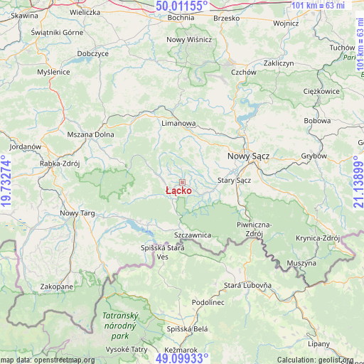
Łącko GPS coordinates[2]
49° 33' 27.252" North, 20° 26' 9.096" East
| Map corner | latitude | longitude |
|---|---|---|
| Upper-left | 50.01155°, | 19.73274° |
| Center: | 49.55757°, | 20.43586° |
| Lower-right: | 49.09933°, | 21.13899° |
| Map W x H: | 101.4×101.4 km | = 63×63mi |
| max Lat: | 54.83135° ⇑97.5% North |
| Łącko: | 49.55757° |
| min Lat: | ⇓2.5% South 49.21328° |
| min Long | Łącko | max Long |
| 14.20249° | 20.43586° | 24.03723° |
| W 64.1%⇐ | ⇒35.9% E |
Elevation
Elevation of Łącko is 364 m = 1194 ft, and this is 172.6 m = 566 ft above average elevation for this country.
| Max E: |
974 m = 3196 ft | 7.4% |
| Łącko | 364 m 1194 ft | |
| Avg. | 191.4 m = 628 ft | |
Min E: |
-3 m = -10 ft | 92.6% |
See also: Poland elevation on elevation.city.
Geographical zone
Łącko is located in North temperate zone (between Tropic of Cancer and the Arctic Circle). Distance of this North polar circle is 1890.9 km =1175 mi to North.| Distance of | km | miles | from Łącko |
|---|---|---|---|
| North Pole | 4496.8 | 2794.2 | to North |
| Arctic Circle | 1890.9 | 1175 | to North |
| Tropic Cancer | 2904.4 | 1804.7 | to South |
| Equator | 5510.3 | 3423.9 | to South |


Nearby cities:
15 places around Łącko: (largest is in red/bold)
• Jastrzębie
4.9 km =3 mi,  37°
37°
• Kamienica
6.8 km =4.2 mi,  286°
286°
• Kluszkowce
15.3 km =9.5 mi,  219°
219°
• Krościenko nad Dunajcem
13 km =8.1 mi,  183°
183°
• Krośnica
14 km =8.7 mi,  209°
209°
• Naszacowice
8.7 km =5.4 mi,  85°
85°
• Ochotnica Dolna
7.5 km =4.7 mi,  243°
243°
• Olszana
6.3 km =3.9 mi,  79°
79°
• Olszanka
7.6 km =4.7 mi, 91°
• Podegrodzie
11.2 km =7 mi, 78°
• Stary Sącz
14.4 km =8.9 mi, 87°
• Szczawnica
15.2 km =9.4 mi,  166°
166°
• Wysokie
13.2 km =8.2 mi, 35°
• Zagorzyn
3 km =1.9 mi,  317°
317°
• Łukowica
6.8 km =4.2 mi,  29°
29°
Sources, notices
• [Note1] Compared only with cities in Poland existing in our database
• [Src1] Map data: © OpenStreetMap contributors (CC-BY-SA)
• [Src2] Other city data from geonames.org with taken over terms of usage.
• [Src3] Geographical zone / Annual Mean Temperature by Robert A. Rohde @ Wikipedia
