Zagorzyn geodata
Zagorzyn (Lesser Poland) is a populated place; located in Poland in Europe/Warsaw (GMT+2) time zone. With population of 888 people, there are 2701 cities with bigger population in this country. Compared to other cities in Poland, 96.9% of cities are located further ↑North; 63.8% of cities are located further ←West and 95.5% of cities have lower elevation than Zagorzyn. Note1


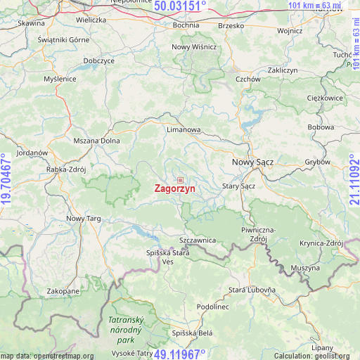
Zagorzyn GPS coordinates[2]
49° 34' 39.792" North, 20° 24' 28.044" East
| Map corner | latitude | longitude |
|---|---|---|
| Upper-left | 50.03151°, | 19.70467° |
| Center: | 49.57772°, | 20.40779° |
| Lower-right: | 49.11967°, | 21.11092° |
| Map W x H: | 101.4×101.4 km | = 63×63mi |
| max Lat: | 54.83135° ⇑96.9% North |
| Zagorzyn: | 49.57772° |
| min Lat: | ⇓3.1% South 49.21328° |
| min Long | Zagorzyn | max Long |
| 14.20249° | 20.40779° | 24.03723° |
| W 63.8%⇐ | ⇒36.2% E |
Elevation
Elevation of Zagorzyn is 428 m = 1404 ft, and this is 236.6 m = 776 ft above average elevation for this country.
| Max E: |
974 m = 3196 ft | 4.5% |
| Zagorzyn | 428 m 1404 ft | |
| Avg. | 191.4 m = 628 ft | |
Min E: |
-3 m = -10 ft | 95.5% |
See also: Poland elevation on elevation.city.
Geographical zone
Zagorzyn is located in North temperate zone (between Tropic of Cancer and the Arctic Circle). Distance of this North polar circle is 1888.6 km =1173.5 mi to North.| Distance of | km | miles | from Zagorzyn |
|---|---|---|---|
| North Pole | 4494.5 | 2792.8 | to North |
| Arctic Circle | 1888.6 | 1173.5 | to North |
| Tropic Cancer | 2906.6 | 1806.1 | to South |
| Equator | 5512.5 | 3425.3 | to South |


Nearby cities:
15 places around Zagorzyn: (largest is in red/bold)
• Jastrzębie
5.3 km =3.3 mi,  71°
71°
• Kamienica
4.5 km =2.8 mi,  266°
266°
• Krościenko nad Dunajcem
15.3 km =9.5 mi,  174°
174°
• Krośnica
15.3 km =9.5 mi,  198°
198°
• Limanowa
14.3 km =8.9 mi,  4°
4°
• Lubomierz
15.2 km =9.4 mi,  283°
283°
• Naszacowice
10.8 km =6.7 mi,  98°
98°
• Ochotnica Dolna
7.4 km =4.6 mi,  219°
219°
• Olszana
8.3 km =5.2 mi, 97°
• Olszanka
10 km =6.2 mi, 103°
• Podegrodzie
13 km =8.1 mi,  90°
90°
• Słopnice
12.8 km =8 mi,  338°
338°
• Wysokie
13 km =8.1 mi,  49°
49°
• Łukowica
6.6 km =4.1 mi,  55°
55°
• Łącko
3 km =1.9 mi,  137°
137°
Sources, notices
• [Note1] Compared only with cities in Poland existing in our database
• [Src1] Map data: © OpenStreetMap contributors (CC-BY-SA)
• [Src2] Other city data from geonames.org with taken over terms of usage.
• [Src3] Geographical zone / Annual Mean Temperature by Robert A. Rohde @ Wikipedia
