Suchedniów geodata
Suchedniów (Świętokrzyskie) is a seat of a third-order administrative division; located in Poland in Europe/Warsaw (GMT+2) time zone. With population of 9,184 people, there are 472 cities with bigger population in this country. Compared to other cities in Poland, 54% of cities are located further ↑North; 69.7% of cities are located further ←West and 79.8% of cities have lower elevation than Suchedniów. Note1


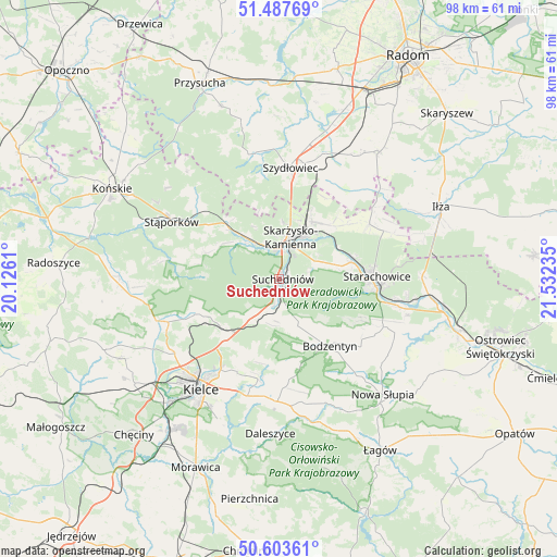
Suchedniów GPS coordinates[2]
51° 2' 51.936" North, 20° 49' 45.192" East
| Map corner | latitude | longitude |
|---|---|---|
| Upper-left | 51.48769°, | 20.1261° |
| Center: | 51.04776°, | 20.82922° |
| Lower-right: | 50.60361°, | 21.53235° |
| Map W x H: | 98.3×98.3 km | = 61.1×61.1mi |
| max Lat: | 54.83135° ⇑54% North |
| Suchedniów: | 51.04776° |
| min Lat: | ⇓46% South 49.21328° |
| min Long | Suchedniów | max Long |
| 14.20249° | 20.82922° | 24.03723° |
| W 69.7%⇐ | ⇒30.3% E |
Elevation
Elevation of Suchedniów is 265 m = 869 ft, and this is 73.6 m = 241 ft above average elevation for this country.
| Max E: |
974 m = 3196 ft | 20.2% |
| Suchedniów | 265 m 869 ft | |
| Avg. | 191.4 m = 628 ft | |
Min E: |
-3 m = -10 ft | 79.8% |
See also: Poland elevation on elevation.city.
Geographical zone
Suchedniów is located in North temperate zone (between Tropic of Cancer and the Arctic Circle). Distance of this North polar circle is 1725.2 km =1072 mi to North.| Distance of | km | miles | from Suchedniów |
|---|---|---|---|
| North Pole | 4331.1 | 2691.2 | to North |
| Arctic Circle | 1725.2 | 1072 | to North |
| Tropic Cancer | 3070.1 | 1907.7 | to South |
| Equator | 5676 | 3526.9 | to South |


Nearby cities:
15 places around Suchedniów: (largest is in red/bold)
• Bliżyn
8.3 km =5.2 mi,  323°
323°
• Bodzentyn
14.9 km =9.3 mi,  142°
142°
• Grzybowa Góra
13.3 km =8.3 mi,  44°
44°
• Gózd
8.4 km =5.2 mi,  212°
212°
• Kaniów
13.5 km =8.4 mi,  239°
239°
• Masłów
18 km =11.2 mi,  204°
204°
• Mirzec
18.6 km =11.6 mi,  58°
58°
• Skarżysko Kościelne
11.6 km =7.2 mi,  29°
29°
• Skarżysko-Kamienna
7.8 km =4.8 mi,  22°
22°
• Starachowice
17 km =10.6 mi,  93°
93°
• Wielka Wieś
9.9 km =6.2 mi,  74°
74°
• Wąchock
13.1 km =8.1 mi,  77°
77°
• Zagnańsk
13.8 km =8.6 mi, 237°
• Łączna
5.5 km =3.4 mi, 203°
• Świerczów
15.8 km =9.8 mi,  298°
298°
Sources, notices
• [Note1] Compared only with cities in Poland existing in our database
• [Src1] Map data: © OpenStreetMap contributors (CC-BY-SA)
• [Src2] Other city data from geonames.org with taken over terms of usage.
• [Src3] Geographical zone / Annual Mean Temperature by Robert A. Rohde @ Wikipedia
