Masłów geodata
Masłów (Świętokrzyskie) is a seat of a third-order administrative division; located in Poland in Europe/Warsaw (GMT+2) time zone. With population of 1,528 people, there are 1820 cities with bigger population in this country. Compared to other cities in Poland, 57.7% of cities are located further ↑North; 68.1% of cities are located further ←West and 85.9% of cities have lower elevation than Masłów. Note1


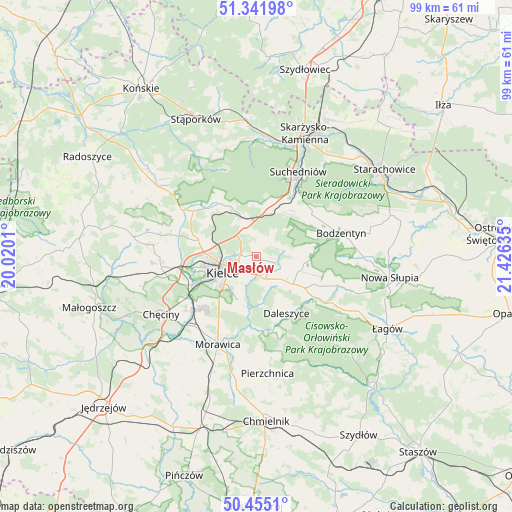
Masłów GPS coordinates[2]
50° 54' 2.34" North, 20° 43' 23.592" East
| Map corner | latitude | longitude |
|---|---|---|
| Upper-left | 51.34198°, | 20.0201° |
| Center: | 50.90065°, | 20.72322° |
| Lower-right: | 50.4551°, | 21.42635° |
| Map W x H: | 98.6×98.6 km | = 61.3×61.3mi |
| max Lat: | 54.83135° ⇑57.7% North |
| Masłów: | 50.90065° |
| min Lat: | ⇓42.3% South 49.21328° |
| min Long | Masłów | max Long |
| 14.20249° | 20.72322° | 24.03723° |
| W 68.1%⇐ | ⇒31.9% E |
Elevation
Elevation of Masłów is 295 m = 968 ft, and this is 103.6 m = 340 ft above average elevation for this country.
| Max E: |
974 m = 3196 ft | 14.1% |
| Masłów | 295 m 968 ft | |
| Avg. | 191.4 m = 628 ft | |
Min E: |
-3 m = -10 ft | 85.9% |
See also: Poland elevation on elevation.city.
Geographical zone
Masłów is located in North temperate zone (between Tropic of Cancer and the Arctic Circle). Distance of this North polar circle is 1741.6 km =1082.2 mi to North.| Distance of | km | miles | from Masłów |
|---|---|---|---|
| North Pole | 4347.4 | 2701.3 | to North |
| Arctic Circle | 1741.6 | 1082.2 | to North |
| Tropic Cancer | 3053.7 | 1897.5 | to South |
| Equator | 5659.6 | 3516.7 | to South |


Nearby cities:
15 places around Masłów: (largest is in red/bold)
• Bieliny
16.3 km =10.1 mi,  110°
110°
• Bodzentyn
17 km =10.6 mi,  74°
74°
• Daleszyce
12.4 km =7.7 mi,  151°
151°
• Domaszowice
4 km =2.5 mi,  224°
224°
• Górno
9.3 km =5.8 mi,  129°
129°
• Gózd
9.7 km =6 mi,  17°
17°
• Kaniów
10.3 km =6.4 mi,  336°
336°
• Kielce
7.5 km =4.7 mi,  243°
243°
• Kostomłoty Drugie
11.4 km =7.1 mi,  284°
284°
• Kostomłoty Pierwsze
9.3 km =5.8 mi,  285°
285°
• Miedziana Góra
12.7 km =7.9 mi, 288°
• Osiedle-Nowiny
15.8 km =9.8 mi,  234°
234°
• Wola Jachowa
11.3 km =7 mi,  123°
123°
• Zagnańsk
9.8 km =6.1 mi,  334°
334°
• Łączna
12.4 km =7.7 mi, 24°
Sources, notices
• [Note1] Compared only with cities in Poland existing in our database
• [Src1] Map data: © OpenStreetMap contributors (CC-BY-SA)
• [Src2] Other city data from geonames.org with taken over terms of usage.
• [Src3] Geographical zone / Annual Mean Temperature by Robert A. Rohde @ Wikipedia
