Bodzentyn geodata
Bodzentyn (Świętokrzyskie) is a seat of a third-order administrative division; located in Poland in Europe/Warsaw (GMT+2) time zone. With population of 2,228 people, there are 1347 cities with bigger population in this country. Compared to other cities in Poland, 56.6% of cities are located further ↑North; 71.8% of cities are located further ←West and 84.4% of cities have lower elevation than Bodzentyn. Note1


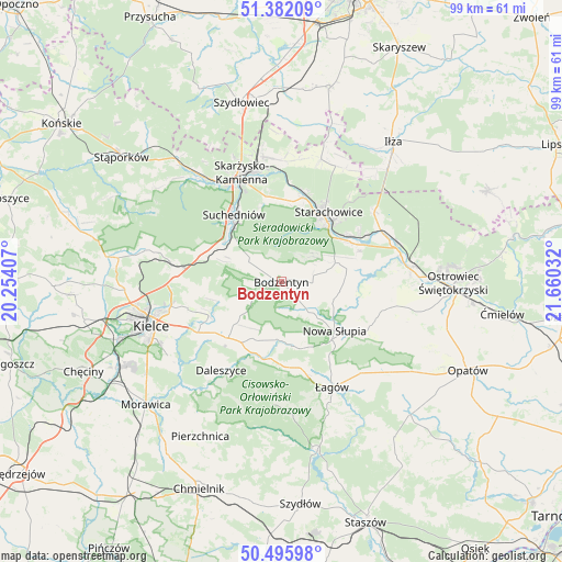
Bodzentyn GPS coordinates[2]
50° 56' 28.14" North, 20° 57' 25.884" East
| Map corner | latitude | longitude |
|---|---|---|
| Upper-left | 51.38209°, | 20.25407° |
| Center: | 50.94115°, | 20.95719° |
| Lower-right: | 50.49598°, | 21.66032° |
| Map W x H: | 98.5×98.5 km | = 61.2×61.2mi |
| max Lat: | 54.83135° ⇑56.6% North |
| Bodzentyn: | 50.94115° |
| min Lat: | ⇓43.4% South 49.21328° |
| min Long | Bodzentyn | max Long |
| 14.20249° | 20.95719° | 24.03723° |
| W 71.8%⇐ | ⇒28.2% E |
Elevation
Elevation of Bodzentyn is 287 m = 942 ft, and this is 95.6 m = 314 ft above average elevation for this country.
| Max E: |
974 m = 3196 ft | 15.6% |
| Bodzentyn | 287 m 942 ft | |
| Avg. | 191.4 m = 628 ft | |
Min E: |
-3 m = -10 ft | 84.4% |
See also: Poland elevation on elevation.city.
Geographical zone
Bodzentyn is located in North temperate zone (between Tropic of Cancer and the Arctic Circle). Distance of this North polar circle is 1737 km =1079.3 mi to North.| Distance of | km | miles | from Bodzentyn |
|---|---|---|---|
| North Pole | 4342.9 | 2698.6 | to North |
| Arctic Circle | 1737 | 1079.3 | to North |
| Tropic Cancer | 3058.2 | 1900.3 | to South |
| Equator | 5664.1 | 3519.5 | to South |


Nearby cities:
15 places around Bodzentyn: (largest is in red/bold)
• Bieliny
10.3 km =6.4 mi,  186°
186°
• Górno
13.9 km =8.6 mi,  221°
221°
• Gózd
14.2 km =8.8 mi,  289°
289°
• Nowa Słupia
12.7 km =7.9 mi,  132°
132°
• Pawłów
11.7 km =7.3 mi,  78°
78°
• Rzepin Drugi
12.1 km =7.5 mi,  69°
69°
• Rzepin Pierwszy
9.6 km =6 mi,  60°
60°
• Sosnówka
10.1 km =6.3 mi,  115°
115°
• Stara Słupia
13.5 km =8.4 mi, 122°
• Starachowice
13.4 km =8.3 mi,  36°
36°
• Suchedniów
14.9 km =9.3 mi,  322°
322°
• Wielka Wieś
14.5 km =9 mi,  2°
2°
• Wola Jachowa
12.7 km =7.9 mi,  213°
213°
• Wąchock
15.3 km =9.5 mi,  14°
14°
• Łączna
13.1 km =8.1 mi,  301°
301°
Sources, notices
• [Note1] Compared only with cities in Poland existing in our database
• [Src1] Map data: © OpenStreetMap contributors (CC-BY-SA)
• [Src2] Other city data from geonames.org with taken over terms of usage.
• [Src3] Geographical zone / Annual Mean Temperature by Robert A. Rohde @ Wikipedia
