Skarżysko Kościelne geodata
Skarżysko Kościelne (Świętokrzyskie) is a seat of a third-order administrative division; located in Poland in Europe/Warsaw (GMT+2) time zone. With population of 2,700 people, there are 1159 cities with bigger population in this country. Compared to other cities in Poland, 51.1% of cities are located further ↑North; 71% of cities are located further ←West and 71.6% of cities have lower elevation than Skarżysko Kościelne. Note1
Administrative division(s):
- Level 1: Świętokrzyskie
- Level 2: Powiat skarżyski
- Level 3: Skarżysko Kościelne


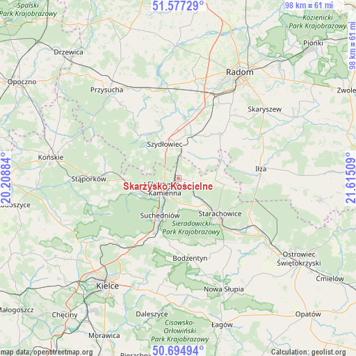
Skarżysko Kościelne GPS coordinates[2]
51° 8' 17.592" North, 20° 54' 43.056" East
| Map corner | latitude | longitude |
|---|---|---|
| Upper-left | 51.57729°, | 20.20884° |
| Center: | 51.13822°, | 20.91196° |
| Lower-right: | 50.69494°, | 21.61509° |
| Map W x H: | 98.1×98.1 km | = 61×61mi |
| max Lat: | 54.83135° ⇑51.1% North |
| Skarżysko Kościelne: | 51.13822° |
| min Lat: | ⇓48.9% South 49.21328° |
| min Long | Skarżysko Koś | max Long |
| 14.20249° | 20.91196° | 24.03723° |
| W 71%⇐ | ⇒29% E |
Elevation
Elevation of Skarżysko Kościelne is 234 m = 768 ft, and this is 42.6 m = 140 ft above average elevation for this country.
| Max E: |
974 m = 3196 ft | 28.4% |
| Skarżysko Kościelne | 234 m 768 ft | |
| Avg. | 191.4 m = 628 ft | |
Min E: |
-3 m = -10 ft | 71.6% |
See also: Poland elevation on elevation.city.
Geographical zone
Skarżysko Kościelne is located in North temperate zone (between Tropic of Cancer and the Arctic Circle). Distance of this North polar circle is 1715.1 km =1065.7 mi to North.| Distance of | km | miles | from Skarżysko Kościelne |
|---|---|---|---|
| North Pole | 4321 | 2684.9 | to North |
| Arctic Circle | 1715.1 | 1065.7 | to North |
| Tropic Cancer | 3080.1 | 1913.9 | to South |
| Equator | 5686 | 3533.1 | to South |


Nearby cities:
15 places around Skarżysko Kościelne: (largest is in red/bold)
• Bliżyn
11.2 km =7 mi,  252°
252°
• Chlewiska
15.4 km =9.6 mi,  319°
319°
• Grzybowa Góra
3.5 km =2.2 mi,  99°
99°
• Jastrząb
12.4 km =7.7 mi,  11°
11°
• Mirzec
10.1 km =6.3 mi,  92°
92°
• Mirów
10.7 km =6.6 mi,  52°
52°
• Mirów Stary
10.6 km =6.6 mi,  59°
59°
• Pawłów
14.5 km =9 mi,  332°
332°
• Rogów
9.5 km =5.9 mi, 45°
• Skarżysko-Kamienna
4 km =2.5 mi,  225°
225°
• Starachowice
15.8 km =9.8 mi,  135°
135°
• Suchedniów
11.6 km =7.2 mi,  209°
209°
• Szydłowiec
10.6 km =6.6 mi,  340°
340°
• Wielka Wieś
8.4 km =5.2 mi,  152°
152°
• Wąchock
10 km =6.2 mi, 135°
Sources, notices
• [Note1] Compared only with cities in Poland existing in our database
• [Src1] Map data: © OpenStreetMap contributors (CC-BY-SA)
• [Src2] Other city data from geonames.org with taken over terms of usage.
• [Src3] Geographical zone / Annual Mean Temperature by Robert A. Rohde @ Wikipedia
