Gózd geodata
Gózd (Świętokrzyskie) is a populated place; located in Poland in Europe/Warsaw (GMT+2) time zone. With population of 560 people, there are 3377 cities with bigger population in this country. Compared to other cities in Poland, 55.6% of cities are located further ↑North; 68.7% of cities are located further ←West and 92.8% of cities have lower elevation than Gózd. Note1


Gózd GPS coordinates[2]
50° 59' 1.968" North, 20° 45' 56.556" East
| Map corner | latitude | longitude |
|---|---|---|
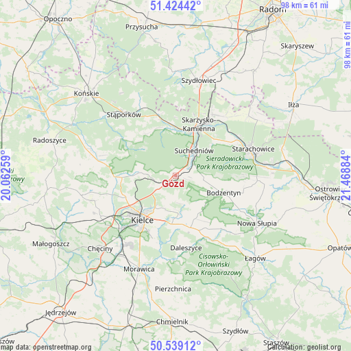
| Upper-left | 51.42442°, | 20.06259° |
| Center: | 50.98388°, | 20.76571° |
| Lower-right: | 50.53912°, | 21.46884° |
| Map W x H: | 98.4×98.4 km | = 61.1×61.1mi |
| max Lat: | 54.83135° ⇑55.6% North |
| Gózd: | 50.98388° |
| min Lat: | ⇓44.4% South 49.21328° |
| min Long | Gózd | max Long |
| 14.20249° | 20.76571° | 24.03723° |
| W 68.7%⇐ | ⇒31.3% E |
Elevation
Elevation of Gózd is 367 m = 1204 ft, and this is 175.6 m = 576 ft above average elevation for this country.
| Max E: |
974 m = 3196 ft | 7.2% |
| Gózd | 367 m 1204 ft | |
| Avg. | 191.4 m = 628 ft | |
Min E: |
-3 m = -10 ft | 92.8% |
See also: Poland elevation on elevation.city.
Geographical zone
Gózd is located in North temperate zone (between Tropic of Cancer and the Arctic Circle). Distance of this North polar circle is 1732.3 km =1076.4 mi to North.| Distance of | km | miles | from Gózd |
|---|---|---|---|
| North Pole | 4338.2 | 2695.6 | to North |
| Arctic Circle | 1732.3 | 1076.4 | to North |
| Tropic Cancer | 3063 | 1903.3 | to South |
| Equator | 5668.9 | 3522.5 | to South |


Nearby cities:
15 places around Gózd: (largest is in red/bold)
• Bliżyn
13.8 km =8.6 mi,  358°
358°
• Bodzentyn
14.2 km =8.8 mi,  109°
109°
• Domaszowice
13.4 km =8.3 mi,  205°
205°
• Górno
15.7 km =9.8 mi,  164°
164°
• Kaniów
7.1 km =4.4 mi,  271°
271°
• Kielce
15.9 km =9.9 mi,  217°
217°
• Kostomłoty Drugie
15.4 km =9.6 mi,  245°
245°
• Kostomłoty Pierwsze
13.7 km =8.5 mi,  240°
240°
• Masłów
9.7 km =6 mi,  197°
197°
• Miedziana Góra
15.9 km =9.9 mi, 250°
• Skarżysko-Kamienna
16.2 km =10.1 mi,  27°
27°
• Suchedniów
8.4 km =5.2 mi, 32°
• Wola Jachowa
16.7 km =10.4 mi, 157°
• Zagnańsk
7.2 km =4.5 mi, 266°
• Łączna
3 km =1.9 mi,  47°
47°
Sources, notices
• [Note1] Compared only with cities in Poland existing in our database
• [Src1] Map data: © OpenStreetMap contributors (CC-BY-SA)
• [Src2] Other city data from geonames.org with taken over terms of usage.
• [Src3] Geographical zone / Annual Mean Temperature by Robert A. Rohde @ Wikipedia
