Mirzec geodata
Mirzec (Świętokrzyskie) is a seat of a third-order administrative division; located in Poland in Europe/Warsaw (GMT+2) time zone. With population of 2,100 people, there are 1411 cities with bigger population in this country. Compared to other cities in Poland, 51.3% of cities are located further ↑North; 73.7% of cities are located further ←West and 64.8% of cities have lower elevation than Mirzec. Note1


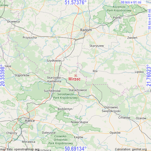
Mirzec GPS coordinates[2]
51° 8' 4.776" North, 21° 3' 25.56" East
| Map corner | latitude | longitude |
|---|---|---|
| Upper-left | 51.57376°, | 20.35398° |
| Center: | 51.13466°, | 21.0571° |
| Lower-right: | 50.69134°, | 21.76023° |
| Map W x H: | 98.1×98.1 km | = 61×61mi |
| max Lat: | 54.83135° ⇑51.3% North |
| Mirzec: | 51.13466° |
| min Lat: | ⇓48.7% South 49.21328° |
| min Long | Mirzec | max Long |
| 14.20249° | 21.0571° | 24.03723° |
| W 73.7%⇐ | ⇒26.3% E |
Elevation
Elevation of Mirzec is 214 m = 702 ft, and this is 22.6 m = 74 ft above average elevation for this country.
| Max E: |
974 m = 3196 ft | 35.2% |
| Mirzec | 214 m 702 ft | |
| Avg. | 191.4 m = 628 ft | |
Min E: |
-3 m = -10 ft | 64.8% |
See also: Poland elevation on elevation.city.
Geographical zone
Mirzec is located in North temperate zone (between Tropic of Cancer and the Arctic Circle). Distance of this North polar circle is 1715.5 km =1066 mi to North.| Distance of | km | miles | from Mirzec |
|---|---|---|---|
| North Pole | 4321.4 | 2685.2 | to North |
| Arctic Circle | 1715.5 | 1066 | to North |
| Tropic Cancer | 3079.7 | 1913.6 | to South |
| Equator | 5685.6 | 3532.9 | to South |


Nearby cities:
15 places around Mirzec: (largest is in red/bold)
• Adamów
14.3 km =8.9 mi,  153°
153°
• Grzybowa Góra
6.7 km =4.2 mi,  268°
268°
• Iłża
13.1 km =8.1 mi,  76°
76°
• Jastrząb
14.7 km =9.1 mi,  328°
328°
• Mirów
7.2 km =4.5 mi,  346°
346°
• Mirów Stary
5.8 km =3.6 mi, 350°
• Pakosław
10.4 km =6.5 mi,  52°
52°
• Rogów
7.9 km =4.9 mi, 334°
• Rzeczków
14.7 km =9.1 mi,  0°
0°
• Skarżysko Kościelne
10.1 km =6.3 mi, 272°
• Skarżysko-Kamienna
13.2 km =8.2 mi,  259°
259°
• Starachowice
10.9 km =6.8 mi,  174°
174°
• Wielka Wieś
9.5 km =5.9 mi,  221°
221°
• Wierzbica
12.9 km =8 mi,  7°
7°
• Wąchock
7.4 km =4.6 mi,  204°
204°
Sources, notices
• [Note1] Compared only with cities in Poland existing in our database
• [Src1] Map data: © OpenStreetMap contributors (CC-BY-SA)
• [Src2] Other city data from geonames.org with taken over terms of usage.
• [Src3] Geographical zone / Annual Mean Temperature by Robert A. Rohde @ Wikipedia
