Strzyżów geodata
Strzyżów (Subcarpathian) is a seat of a second-order administrative division; located in Poland in Europe/Warsaw (GMT+2) time zone. With population of 8,739 people, there are 486 cities with bigger population in this country. Compared to other cities in Poland, 89% of cities are located further ↑North; 82.2% of cities are located further ←West and 70.9% of cities have lower elevation than Strzyżów. Note1


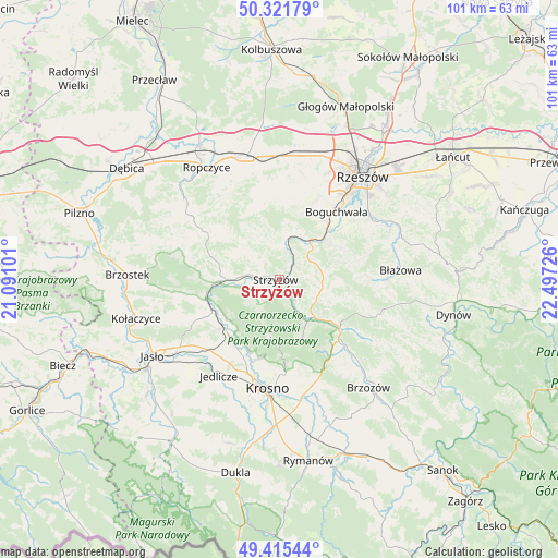
Strzyżów GPS coordinates[2]
49° 52' 14.664" North, 21° 47' 38.868" East
| Map corner | latitude | longitude |
|---|---|---|
| Upper-left | 50.32179°, | 21.09101° |
| Center: | 49.87074°, | 21.79413° |
| Lower-right: | 49.41544°, | 22.49726° |
| Map W x H: | 100.8×100.8 km | = 62.6×62.6mi |
| max Lat: | 54.83135° ⇑89% North |
| Strzyżów: | 49.87074° |
| min Lat: | ⇓11% South 49.21328° |
| min Long | Strzyżów | max Long |
| 14.20249° | 21.79413° | 24.03723° |
| W 82.2%⇐ | ⇒17.8% E |
Elevation
Elevation of Strzyżów is 232 m = 761 ft, and this is 40.6 m = 133 ft above average elevation for this country.
| Max E: |
974 m = 3196 ft | 29.1% |
| Strzyżów | 232 m 761 ft | |
| Avg. | 191.4 m = 628 ft | |
Min E: |
-3 m = -10 ft | 70.9% |
See also: Poland elevation on elevation.city.
Geographical zone
Strzyżów is located in North temperate zone (between Tropic of Cancer and the Arctic Circle). Distance of this North polar circle is 1856.1 km =1153.3 mi to North.| Distance of | km | miles | from Strzyżów |
|---|---|---|---|
| North Pole | 4462 | 2772.6 | to North |
| Arctic Circle | 1856.1 | 1153.3 | to North |
| Tropic Cancer | 2939.2 | 1826.3 | to South |
| Equator | 5545.1 | 3445.6 | to South |


Nearby cities:
15 places around Strzyżów: (largest is in red/bold)
• Babica
9 km =5.6 mi,  37°
37°
• Bystrzyca
12.8 km =8 mi,  338°
338°
• Czudec
8.9 km =5.5 mi,  22°
22°
• Frysztak
13.6 km =8.5 mi,  256°
256°
• Jawornik
7.7 km =4.8 mi,  110°
110°
• Konieczkowa
10.1 km =6.3 mi, 108°
• Krasna
11.4 km =7.1 mi,  158°
158°
• Lubenia
11.6 km =7.2 mi,  54°
54°
• Niebylec
8 km =5 mi,  101°
101°
• Połomia
8 km =5 mi,  61°
61°
• Wiśniowa
10 km =6.2 mi,  268°
268°
• Wojaszówka
13.6 km =8.5 mi,  220°
220°
• Wysoka Strzyżowska
5.9 km =3.7 mi, 220°
• Zarzecze
12.6 km =7.8 mi, 44°
• Łęki
11.7 km =7.3 mi,  234°
234°
Sources, notices
• [Note1] Compared only with cities in Poland existing in our database
• [Src1] Map data: © OpenStreetMap contributors (CC-BY-SA)
• [Src2] Other city data from geonames.org with taken over terms of usage.
• [Src3] Geographical zone / Annual Mean Temperature by Robert A. Rohde @ Wikipedia
