Zarzecze geodata
Zarzecze (Subcarpathian) is a populated place; located in Poland in Europe/Warsaw (GMT+2) time zone. With population of 511 people, there are 3512 cities with bigger population in this country. Compared to other cities in Poland, 85.4% of cities are located further ↑North; 83.7% of cities are located further ←West and 63.8% of cities have lower elevation than Zarzecze. Note1


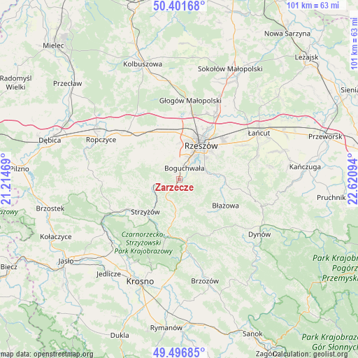
Zarzecze GPS coordinates[2]
49° 57' 5.004" North, 21° 55' 4.116" East
| Map corner | latitude | longitude |
|---|---|---|
| Upper-left | 50.40168°, | 21.21469° |
| Center: | 49.95139°, | 21.91781° |
| Lower-right: | 49.49685°, | 22.62094° |
| Map W x H: | 100.6×100.6 km | = 62.5×62.5mi |
| max Lat: | 54.83135° ⇑85.4% North |
| Zarzecze: | 49.95139° |
| min Lat: | ⇓14.6% South 49.21328° |
| min Long | Zarzecze | max Long |
| 14.20249° | 21.91781° | 24.03723° |
| W 83.7%⇐ | ⇒16.3% E |
Elevation
Elevation of Zarzecze is 211 m = 692 ft, and this is 19.6 m = 64 ft above average elevation for this country.
| Max E: |
974 m = 3196 ft | 36.2% |
| Zarzecze | 211 m 692 ft | |
| Avg. | 191.4 m = 628 ft | |
Min E: |
-3 m = -10 ft | 63.8% |
See also: Poland elevation on elevation.city.
Geographical zone
Zarzecze is located in North temperate zone (between Tropic of Cancer and the Arctic Circle). Distance of this North polar circle is 1847.1 km =1147.7 mi to North.| Distance of | km | miles | from Zarzecze |
|---|---|---|---|
| North Pole | 4453 | 2767 | to North |
| Arctic Circle | 1847.1 | 1147.7 | to North |
| Tropic Cancer | 2948.2 | 1831.9 | to South |
| Equator | 5554.1 | 3451.2 | to South |


Nearby cities:
15 places around Zarzecze: (largest is in red/bold)
• Babica
3.9 km =2.4 mi,  241°
241°
• Boguchwała
4.2 km =2.6 mi,  27°
27°
• Czudec
5.5 km =3.4 mi,  262°
262°
• Kielanówka
8.4 km =5.2 mi,  5°
5°
• Lecka
10.6 km =6.6 mi,  139°
139°
• Lubenia
2.4 km =1.5 mi,  164°
164°
• Lutoryż
1.8 km =1.1 mi,  347°
347°
• Niebylec
10.6 km =6.6 mi,  185°
185°
• Niechobrz
5.6 km =3.5 mi,  329°
329°
• Połomia
5.5 km =3.4 mi,  199°
199°
• Przybyszówka
10.7 km =6.6 mi,  3°
3°
• Siedliska
2.1 km =1.3 mi,  81°
81°
• Straszydle
7.3 km =4.5 mi, 141°
• Tyczyn
8.4 km =5.2 mi, 80°
• Zgłobień
8.2 km =5.1 mi, 326°
Sources, notices
• [Note1] Compared only with cities in Poland existing in our database
• [Src1] Map data: © OpenStreetMap contributors (CC-BY-SA)
• [Src2] Other city data from geonames.org with taken over terms of usage.
• [Src3] Geographical zone / Annual Mean Temperature by Robert A. Rohde @ Wikipedia
