Łęki geodata
Łęki (Subcarpathian) is a populated place; located in Poland in Europe/Warsaw (GMT+2) time zone. With population of 1,088 people, there are 2372 cities with bigger population in this country. Compared to other cities in Poland, 91.4% of cities are located further ↑North; 80.8% of cities are located further ←West and 79.7% of cities have lower elevation than Łęki. Note1


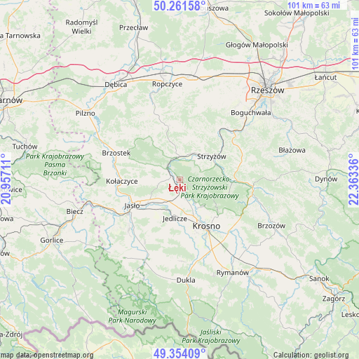
Łęki GPS coordinates[2]
49° 48' 35.856" North, 21° 39' 36.828" East
| Map corner | latitude | longitude |
|---|---|---|
| Upper-left | 50.26158°, | 20.95711° |
| Center: | 49.80996°, | 21.66023° |
| Lower-right: | 49.35409°, | 22.36336° |
| Map W x H: | 100.9×100.9 km | = 62.7×62.7mi |
| max Lat: | 54.83135° ⇑91.4% North |
| Łęki: | 49.80996° |
| min Lat: | ⇓8.6% South 49.21328° |
| min Long | Łęki | max Long |
| 14.20249° | 21.66023° | 24.03723° |
| W 80.8%⇐ | ⇒19.2% E |
Elevation
Elevation of Łęki is 264 m = 866 ft, and this is 72.6 m = 238 ft above average elevation for this country.
| Max E: |
974 m = 3196 ft | 20.3% |
| Łęki | 264 m 866 ft | |
| Avg. | 191.4 m = 628 ft | |
Min E: |
-3 m = -10 ft | 79.7% |
See also: Poland elevation on elevation.city.
Geographical zone
Łęki is located in North temperate zone (between Tropic of Cancer and the Arctic Circle). Distance of this North polar circle is 1862.8 km =1157.5 mi to North.| Distance of | km | miles | from Łęki |
|---|---|---|---|
| North Pole | 4468.7 | 2776.7 | to North |
| Arctic Circle | 1862.8 | 1157.5 | to North |
| Tropic Cancer | 2932.4 | 1822.1 | to South |
| Equator | 5538.3 | 3441.3 | to South |


Nearby cities:
15 places around Łęki: (largest is in red/bold)
• Frysztak
5.1 km =3.2 mi,  314°
314°
• Jasło
15.3 km =9.5 mi,  241°
241°
• Jawornik
17.3 km =10.7 mi,  76°
76°
• Jedlicze
10.3 km =6.4 mi,  184°
184°
• Korczyna
15 km =9.3 mi,  134°
134°
• Kołaczyce
16.2 km =10.1 mi,  269°
269°
• Krasna
14.3 km =8.9 mi,  105°
105°
• Krosno
15.6 km =9.7 mi,  149°
149°
• Odrzykoń
9.6 km =6 mi,  143°
143°
• Strzyżów
11.7 km =7.3 mi,  54°
54°
• Tarnowiec
10.6 km =6.6 mi,  214°
214°
• Wielopole Skrzyńskie
15.4 km =9.6 mi,  347°
347°
• Wiśniowa
6.6 km =4.1 mi,  356°
356°
• Wojaszówka
3.7 km =2.3 mi,  168°
168°
• Wysoka Strzyżowska
6.2 km =3.9 mi,  68°
68°
Sources, notices
• [Note1] Compared only with cities in Poland existing in our database
• [Src1] Map data: © OpenStreetMap contributors (CC-BY-SA)
• [Src2] Other city data from geonames.org with taken over terms of usage.
• [Src3] Geographical zone / Annual Mean Temperature by Robert A. Rohde @ Wikipedia
