Stary Zamość geodata
Stary Zamość (Lublin) is a seat of a third-order administrative division; located in Poland in Europe/Warsaw (GMT+2) time zone. With population of 637 people, there are 3196 cities with bigger population in this country. Compared to other cities in Poland, 59.7% of cities are located further ↑North; 97.2% of cities are located further ←West and 61.5% of cities have lower elevation than Stary Zamość. Note1


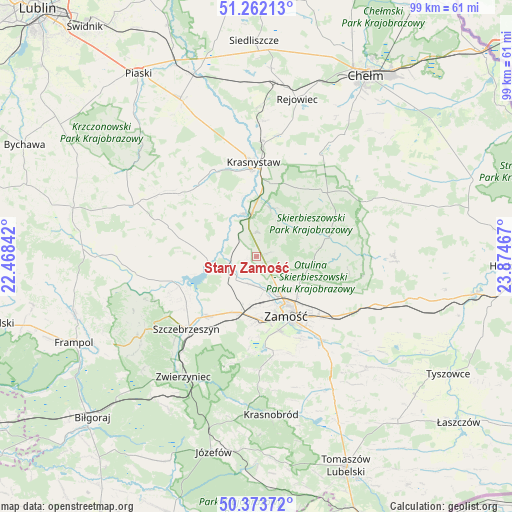
Stary Zamość GPS coordinates[2]
50° 49' 12.144" North, 23° 10' 17.544" East
| Map corner | latitude | longitude |
|---|---|---|
| Upper-left | 51.26213°, | 22.46842° |
| Center: | 50.82004°, | 23.17154° |
| Lower-right: | 50.37372°, | 23.87467° |
| Map W x H: | 98.8×98.8 km | = 61.4×61.4mi |
| max Lat: | 54.83135° ⇑59.7% North |
| Stary Zamość: | 50.82004° |
| min Lat: | ⇓40.3% South 49.21328° |
| min Long | Stary Zamość | max Long |
| 14.20249° | 23.17154° | 24.03723° |
| W 97.2%⇐ | ⇒2.8% E |
Elevation
Elevation of Stary Zamość is 204 m = 669 ft, and this is 12.6 m = 41 ft above average elevation for this country.
| Max E: |
974 m = 3196 ft | 38.5% |
| Stary Zamość | 204 m 669 ft | |
| Avg. | 191.4 m = 628 ft | |
Min E: |
-3 m = -10 ft | 61.5% |
See also: Poland elevation on elevation.city.
Geographical zone
Stary Zamość is located in North temperate zone (between Tropic of Cancer and the Arctic Circle). Distance of this North polar circle is 1750.5 km =1087.7 mi to North.| Distance of | km | miles | from Stary Zamość |
|---|---|---|---|
| North Pole | 4356.4 | 2706.9 | to North |
| Arctic Circle | 1750.5 | 1087.7 | to North |
| Tropic Cancer | 3044.7 | 1891.9 | to South |
| Equator | 5650.7 | 3511.2 | to South |


Nearby cities:
15 places around Stary Zamość: (largest is in red/bold)
• Dębowiec
11.5 km =7.1 mi,  102°
102°
• Gorzków
18.1 km =11.2 mi,  321°
321°
• Izbica
7.6 km =4.7 mi,  349°
349°
• Krasne
4.9 km =3 mi,  0°
0°
• Krasnystaw
18.3 km =11.4 mi, 0°
• Kraśniczyn
17.6 km =10.9 mi,  45°
45°
• Michałów
13.9 km =8.6 mi,  228°
228°
• Nielisz
9.2 km =5.7 mi,  256°
256°
• Rudnik
15.5 km =9.6 mi,  295°
295°
• Sitno
15.6 km =9.7 mi,  120°
120°
• Skierbieszów
13.6 km =8.5 mi,  75°
75°
• Sułów
16.1 km =10 mi,  250°
250°
• Szczebrzeszyn
19.4 km =12.1 mi,  224°
224°
• Wysokie
8.2 km =5.1 mi,  154°
154°
• Zamość
12.2 km =7.6 mi, 152°
Sources, notices
• [Note1] Compared only with cities in Poland existing in our database
• [Src1] Map data: © OpenStreetMap contributors (CC-BY-SA)
• [Src2] Other city data from geonames.org with taken over terms of usage.
• [Src3] Geographical zone / Annual Mean Temperature by Robert A. Rohde @ Wikipedia
