Nielisz geodata
Nielisz (Lublin) is a seat of a third-order administrative division; located in Poland in Europe/Warsaw (GMT+2) time zone. With population of 920 people, there are 2637 cities with bigger population in this country. Compared to other cities in Poland, 60.1% of cities are located further ↑North; 96.5% of cities are located further ←West and 62.4% of cities have lower elevation than Nielisz. Note1


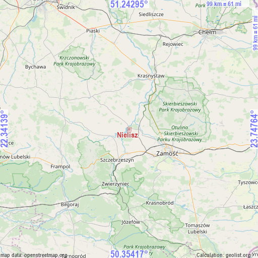
Nielisz GPS coordinates[2]
50° 48' 2.412" North, 23° 2' 40.236" East
| Map corner | latitude | longitude |
|---|---|---|
| Upper-left | 51.24295°, | 22.34139° |
| Center: | 50.80067°, | 23.04451° |
| Lower-right: | 50.35417°, | 23.74764° |
| Map W x H: | 98.8×98.8 km | = 61.4×61.4mi |
| max Lat: | 54.83135° ⇑60.1% North |
| Nielisz: | 50.80067° |
| min Lat: | ⇓39.9% South 49.21328° |
| min Long | Nielisz | max Long |
| 14.20249° | 23.04451° | 24.03723° |
| W 96.5%⇐ | ⇒3.5% E |
Elevation
Elevation of Nielisz is 207 m = 679 ft, and this is 15.6 m = 51 ft above average elevation for this country.
| Max E: |
974 m = 3196 ft | 37.6% |
| Nielisz | 207 m 679 ft | |
| Avg. | 191.4 m = 628 ft | |
Min E: |
-3 m = -10 ft | 62.4% |
See also: Poland elevation on elevation.city.
Geographical zone
Nielisz is located in North temperate zone (between Tropic of Cancer and the Arctic Circle). Distance of this North polar circle is 1752.7 km =1089.1 mi to North.| Distance of | km | miles | from Nielisz |
|---|---|---|---|
| North Pole | 4358.6 | 2708.3 | to North |
| Arctic Circle | 1752.7 | 1089.1 | to North |
| Tropic Cancer | 3042.6 | 1890.6 | to South |
| Equator | 5648.5 | 3509.8 | to South |


Nearby cities:
15 places around Nielisz: (largest is in red/bold)
• Dębowiec
20.2 km =12.6 mi,  90°
90°
• Gorzków
16.5 km =10.3 mi,  352°
352°
• Izbica
12.3 km =7.6 mi,  38°
38°
• Kawęczyn
15.6 km =9.7 mi,  206°
206°
• Krasne
11.4 km =7.1 mi,  52°
52°
• Michałów
7.2 km =4.5 mi,  192°
192°
• Radecznica
16.1 km =10 mi,  250°
250°
• Rudnik
10.2 km =6.3 mi,  330°
330°
• Stary Zamość
9.2 km =5.7 mi,  76°
76°
• Sułów
7 km =4.3 mi,  242°
242°
• Szczebrzeszyn
12.6 km =7.8 mi,  201°
201°
• Wysokie
13.6 km =8.5 mi,  112°
112°
• Zamość
16.9 km =10.5 mi,  120°
120°
• Żabno
19.9 km =12.4 mi,  287°
287°
• Żółkiewka
19.1 km =11.9 mi,  309°
309°
Sources, notices
• [Note1] Compared only with cities in Poland existing in our database
• [Src1] Map data: © OpenStreetMap contributors (CC-BY-SA)
• [Src2] Other city data from geonames.org with taken over terms of usage.
• [Src3] Geographical zone / Annual Mean Temperature by Robert A. Rohde @ Wikipedia
