Dębowiec geodata
Dębowiec (Lublin) is a populated place; located in Poland in Europe/Warsaw (GMT+2) time zone. With population of 682 people, there are 3105 cities with bigger population in this country. Compared to other cities in Poland, 60.2% of cities are located further ↑North; 98% of cities are located further ←West and 79.2% of cities have lower elevation than Dębowiec. Note1


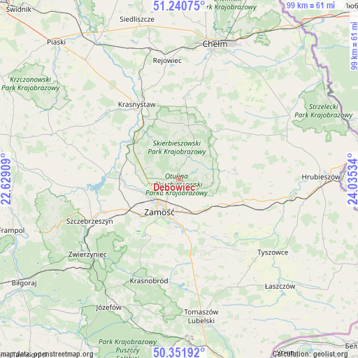
Dębowiec GPS coordinates[2]
50° 47' 54.42" North, 23° 19' 55.956" East
| Map corner | latitude | longitude |
|---|---|---|
| Upper-left | 51.24075°, | 22.62909° |
| Center: | 50.79845°, | 23.33221° |
| Lower-right: | 50.35192°, | 24.03534° |
| Map W x H: | 98.8×98.8 km | = 61.4×61.4mi |
| max Lat: | 54.83135° ⇑60.2% North |
| Dębowiec: | 50.79845° |
| min Lat: | ⇓39.8% South 49.21328° |
| min Long | Dębowiec | max Long |
| 14.20249° | 23.33221° | 24.03723° |
| W 98%⇐ | ⇒2% E |
Elevation
Elevation of Dębowiec is 262 m = 860 ft, and this is 70.6 m = 232 ft above average elevation for this country.
| Max E: |
974 m = 3196 ft | 20.8% |
| Dębowiec | 262 m 860 ft | |
| Avg. | 191.4 m = 628 ft | |
Min E: |
-3 m = -10 ft | 79.2% |
See also: Poland elevation on elevation.city.
Geographical zone
Dębowiec is located in North temperate zone (between Tropic of Cancer and the Arctic Circle). Distance of this North polar circle is 1752.9 km =1089.2 mi to North.| Distance of | km | miles | from Dębowiec |
|---|---|---|---|
| North Pole | 4358.8 | 2708.4 | to North |
| Arctic Circle | 1752.9 | 1089.2 | to North |
| Tropic Cancer | 3042.3 | 1890.4 | to South |
| Equator | 5648.3 | 3509.7 | to South |


Nearby cities:
15 places around Dębowiec: (largest is in red/bold)
• Grabowiec
15.5 km =9.6 mi,  80°
80°
• Izbica
16 km =9.9 mi,  308°
308°
• Komarów-Osada
21.4 km =13.3 mi,  151°
151°
• Krasne
13.4 km =8.3 mi,  302°
302°
• Kraśniczyn
14.9 km =9.3 mi,  4°
4°
• Miączyn
13.6 km =8.5 mi,  119°
119°
• Nielisz
20.2 km =12.6 mi,  270°
270°
• Siennica Różana
22.6 km =14 mi,  358°
358°
• Sitno
5.9 km =3.7 mi,  158°
158°
• Skierbieszów
6.2 km =3.9 mi,  17°
17°
• Stary Zamość
11.5 km =7.1 mi,  282°
282°
• Wojsławice
20.1 km =12.5 mi,  48°
48°
• Wysokie
9.2 km =5.7 mi,  237°
237°
• Zamość
10.1 km =6.3 mi,  213°
213°
• Łabunie
16.1 km =10 mi,  171°
171°
Sources, notices
• [Note1] Compared only with cities in Poland existing in our database
• [Src1] Map data: © OpenStreetMap contributors (CC-BY-SA)
• [Src2] Other city data from geonames.org with taken over terms of usage.
• [Src3] Geographical zone / Annual Mean Temperature by Robert A. Rohde @ Wikipedia
