Platerów geodata
Platerów (Mazovia) is a populated place; located in Poland in Europe/Warsaw (GMT+2) time zone. With population of 798 people, there are 2868 cities with bigger population in this country. Compared to other cities in Poland, 72.5% of cities are located further ↓South; 94.6% of cities are located further ←West and 58.7% of cities have higher elevation than Platerów. Note1


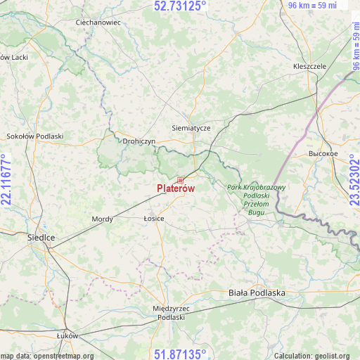
Platerów GPS coordinates[2]
52° 18' 12.204" North, 22° 49' 11.604" East
| Map corner | latitude | longitude |
|---|---|---|
| Upper-left | 52.73125°, | 22.11677° |
| Center: | 52.30339°, | 22.81989° |
| Lower-right: | 51.87135°, | 23.52302° |
| Map W x H: | 95.6×95.6 km | = 59.4×59.4mi |
| max Lat: | 54.83135° ⇑27.5% North |
| Platerów: | 52.30339° |
| min Lat: | ⇓72.5% South 49.21328° |
| min Long | Platerów | max Long |
| 14.20249° | 22.81989° | 24.03723° |
| W 94.6%⇐ | ⇒5.4% E |
Elevation
Elevation of Platerów is 149 m = 489 ft, and this is 42.4 m = 139 ft below average elevation for this country.
| Max E: |
974 m = 3196 ft | 58.7% |
| Avg. | 191.4 m = 628 ft | |
| Platerów | 149 m = 489 ft | |
Min E: |
-3 m = -10 ft | 41.3% |
See also: Poland elevation on elevation.city.
Geographical zone
Platerów is located in North temperate zone (between Tropic of Cancer and the Arctic Circle). Distance of this North polar circle is 1585.6 km =985.2 mi to North.| Distance of | km | miles | from Platerów |
|---|---|---|---|
| North Pole | 4191.5 | 2604.5 | to North |
| Arctic Circle | 1585.6 | 985.2 | to North |
| Tropic Cancer | 3209.7 | 1994.4 | to South |
| Equator | 5815.6 | 3613.6 | to South |


Nearby cities:
15 places around Platerów: (largest is in red/bold)
• Drohiczyn
15.4 km =9.6 mi,  314°
314°
• Huszlew
18.4 km =11.4 mi,  176°
176°
• Janów Podlaski
29.3 km =18.2 mi,  114°
114°
• Konstantynów
21 km =13 mi,  120°
120°
• Korczew
15.1 km =9.4 mi,  291°
291°
• Leśna Podlaska
23.6 km =14.7 mi,  143°
143°
• Mielnik
15.5 km =9.6 mi,  78°
78°
• Mordy
23 km =14.3 mi,  243°
243°
• Nurzec-Stacja
25.3 km =15.7 mi,  45°
45°
• Paprotnia
24 km =14.9 mi,  269°
269°
• Przesmyki
16.5 km =10.3 mi,  256°
256°
• Sarnaki
5 km =3.1 mi,  74°
74°
• Siemiatycze
14.1 km =8.8 mi,  11°
11°
• Stara Kornica
15.7 km =9.8 mi,  149°
149°
• Łosice
12.4 km =7.7 mi,  214°
214°
Sources, notices
• [Note1] Compared only with cities in Poland existing in our database
• [Src1] Map data: © OpenStreetMap contributors (CC-BY-SA)
• [Src2] Other city data from geonames.org with taken over terms of usage.
• [Src3] Geographical zone / Annual Mean Temperature by Robert A. Rohde @ Wikipedia
