Nurzec-Stacja geodata
Nurzec-Stacja (Podlasie) is a populated place; located in Poland in Europe/Warsaw (GMT+2) time zone. With population of 2,000 people, there are 1469 cities with bigger population in this country. Compared to other cities in Poland, 75.8% of cities are located further ↓South; 96.6% of cities are located further ←West and 53.8% of cities have lower elevation than Nurzec-Stacja. Note1


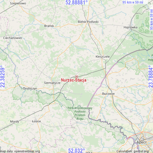
Nurzec-Stacja GPS coordinates[2]
52° 27' 44.964" North, 23° 5' 8.556" East
| Map corner | latitude | longitude |
|---|---|---|
| Upper-left | 52.88881°, | 22.38259° |
| Center: | 52.46249°, | 23.08571° |
| Lower-right: | 52.032°, | 23.78884° |
| Map W x H: | 95.3×95.3 km | = 59.2×59.2mi |
| max Lat: | 54.83135° ⇑24.2% North |
| Nurzec-Stacja: | 52.46249° |
| min Lat: | ⇓75.8% South 49.21328° |
| min Long | Nurzec-Stacja | max Long |
| 14.20249° | 23.08571° | 24.03723° |
| W 96.6%⇐ | ⇒3.4% E |
Elevation
Elevation of Nurzec-Stacja is 182 m = 597 ft, and this is 9.4 m = 31 ft below average elevation for this country.
| Max E: |
974 m = 3196 ft | 46.2% |
| Avg. | 191.4 m = 628 ft | |
| Nurzec-Stacja | 182 m = 597 ft | |
Min E: |
-3 m = -10 ft | 53.8% |
See also: Poland elevation on elevation.city.
Geographical zone
Nurzec-Stacja is located in North temperate zone (between Tropic of Cancer and the Arctic Circle). Distance of this North polar circle is 1567.9 km =974.2 mi to North.| Distance of | km | miles | from Nurzec-Stacja |
|---|---|---|---|
| North Pole | 4173.8 | 2593.5 | to North |
| Arctic Circle | 1567.9 | 974.2 | to North |
| Tropic Cancer | 3227.4 | 2005.4 | to South |
| Equator | 5833.3 | 3624.6 | to South |


Nearby cities:
15 places around Nurzec-Stacja: (largest is in red/bold)
• Boćki
21.2 km =13.2 mi,  352°
352°
• Czeremcha
18.9 km =11.7 mi,  71°
71°
• Drohiczyn
29.8 km =18.5 mi,  256°
256°
• Dziadkowice
16 km =9.9 mi,  314°
314°
• Grodzisk
27.1 km =16.8 mi,  299°
299°
• Janów Podlaski
31.1 km =19.3 mi,  163°
163°
• Kleszczele
20.4 km =12.7 mi,  52°
52°
• Konstantynów
28.4 km =17.6 mi,  180°
180°
• Mielnik
14.8 km =9.2 mi,  191°
191°
• Milejczyce
7.1 km =4.4 mi,  26°
26°
• Orla
31.7 km =19.7 mi, 31°
• Platerów
25.3 km =15.7 mi,  225°
225°
• Sarnaki
21.1 km =13.1 mi,  218°
218°
• Siemiatycze
15.6 km =9.7 mi, 255°
• Stara Kornica
32.8 km =20.4 mi,  197°
197°
Sources, notices
• [Note1] Compared only with cities in Poland existing in our database
• [Src1] Map data: © OpenStreetMap contributors (CC-BY-SA)
• [Src2] Other city data from geonames.org with taken over terms of usage.
• [Src3] Geographical zone / Annual Mean Temperature by Robert A. Rohde @ Wikipedia
