Korczew geodata
Korczew (Mazovia) is a seat of a third-order administrative division; located in Poland in Europe/Warsaw (GMT+2) time zone. With population of 760 people, there are 2931 cities with bigger population in this country. Compared to other cities in Poland, 73.7% of cities are located further ↓South; 92.9% of cities are located further ←West and 58.4% of cities have higher elevation than Korczew. Note1


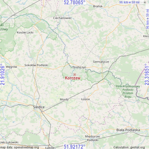
Korczew GPS coordinates[2]
52° 21' 11.772" North, 22° 36' 48.168" East
| Map corner | latitude | longitude |
|---|---|---|
| Upper-left | 52.78065°, | 21.91026° |
| Center: | 52.35327°, | 22.61338° |
| Lower-right: | 51.92172°, | 23.31651° |
| Map W x H: | 95.5×95.5 km | = 59.3×59.3mi |
| max Lat: | 54.83135° ⇑26.3% North |
| Korczew: | 52.35327° |
| min Lat: | ⇓73.7% South 49.21328° |
| min Long | Korczew | max Long |
| 14.20249° | 22.61338° | 24.03723° |
| W 92.9%⇐ | ⇒7.1% E |
Elevation
Elevation of Korczew is 150 m = 492 ft, and this is 41.4 m = 136 ft below average elevation for this country.
| Max E: |
974 m = 3196 ft | 58.4% |
| Avg. | 191.4 m = 628 ft | |
| Korczew | 150 m = 492 ft | |
Min E: |
-3 m = -10 ft | 41.6% |
See also: Poland elevation on elevation.city.
Geographical zone
Korczew is located in North temperate zone (between Tropic of Cancer and the Arctic Circle). Distance of this North polar circle is 1580 km =981.8 mi to North.| Distance of | km | miles | from Korczew |
|---|---|---|---|
| North Pole | 4185.9 | 2601 | to North |
| Arctic Circle | 1580 | 981.8 | to North |
| Tropic Cancer | 3215.2 | 1997.8 | to South |
| Equator | 5821.1 | 3617.1 | to South |


Nearby cities:
15 places around Korczew: (largest is in red/bold)
• Bielany
24.8 km =15.4 mi,  267°
267°
• Drohiczyn
6 km =3.7 mi,  30°
30°
• Jabłonna Lacka
18 km =11.2 mi,  319°
319°
• Mordy
17.1 km =10.6 mi,  202°
202°
• Paprotnia
11.5 km =7.1 mi,  239°
239°
• Perlejewo
24 km =14.9 mi,  352°
352°
• Platerów
15.1 km =9.4 mi,  111°
111°
• Przesmyki
9.7 km =6 mi,  191°
191°
• Repki
15.5 km =9.6 mi,  283°
283°
• Sabnie
26.5 km =16.5 mi,  308°
308°
• Sarnaki
19.3 km =12 mi,  102°
102°
• Siemiatycze
18.8 km =11.7 mi,  64°
64°
• Sokołów Podlaski
25.2 km =15.7 mi, 283°
• Suchożebry
26.6 km =16.5 mi,  246°
246°
• Łosice
17.3 km =10.7 mi,  155°
155°
Sources, notices
• [Note1] Compared only with cities in Poland existing in our database
• [Src1] Map data: © OpenStreetMap contributors (CC-BY-SA)
• [Src2] Other city data from geonames.org with taken over terms of usage.
• [Src3] Geographical zone / Annual Mean Temperature by Robert A. Rohde @ Wikipedia
