Drohiczyn geodata
Drohiczyn (Podlasie) is a seat of a third-order administrative division; located in Poland in Europe/Warsaw (GMT+2) time zone. With population of 2,075 people, there are 1442 cities with bigger population in this country. Compared to other cities in Poland, 74.7% of cities are located further ↓South; 93.4% of cities are located further ←West and 59.9% of cities have higher elevation than Drohiczyn. Note1


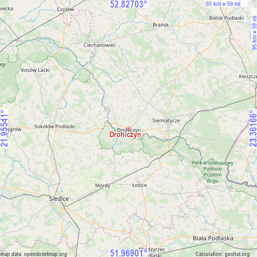
Drohiczyn GPS coordinates[2]
52° 24' 0.396" North, 22° 39' 30.708" East
| Map corner | latitude | longitude |
|---|---|---|
| Upper-left | 52.82703°, | 21.95541° |
| Center: | 52.40011°, | 22.65853° |
| Lower-right: | 51.96901°, | 23.36166° |
| Map W x H: | 95.4×95.4 km | = 59.3×59.3mi |
| max Lat: | 54.83135° ⇑25.3% North |
| Drohiczyn: | 52.40011° |
| min Lat: | ⇓74.7% South 49.21328° |
| min Long | Drohiczyn | max Long |
| 14.20249° | 22.65853° | 24.03723° |
| W 93.4%⇐ | ⇒6.6% E |
Elevation
Elevation of Drohiczyn is 147 m = 482 ft, and this is 44.4 m = 146 ft below average elevation for this country.
| Max E: |
974 m = 3196 ft | 59.9% |
| Avg. | 191.4 m = 628 ft | |
| Drohiczyn | 147 m = 482 ft | |
Min E: |
-3 m = -10 ft | 40.1% |
See also: Poland elevation on elevation.city.
Geographical zone
Drohiczyn is located in North temperate zone (between Tropic of Cancer and the Arctic Circle). Distance of this North polar circle is 1574.8 km =978.5 mi to North.| Distance of | km | miles | from Drohiczyn |
|---|---|---|---|
| North Pole | 4180.7 | 2597.8 | to North |
| Arctic Circle | 1574.8 | 978.5 | to North |
| Tropic Cancer | 3220.4 | 2001.1 | to South |
| Equator | 5826.3 | 3620.3 | to South |


Nearby cities:
15 places around Drohiczyn: (largest is in red/bold)
• Dziadkowice
25.2 km =15.7 mi,  43°
43°
• Grodzisk
21.1 km =13.1 mi,  14°
14°
• Jabłonna Lacka
16.9 km =10.5 mi,  300°
300°
• Korczew
6 km =3.7 mi,  210°
210°
• Mielnik
27.2 km =16.9 mi,  106°
106°
• Mordy
23.1 km =14.4 mi,  204°
204°
• Paprotnia
17 km =10.6 mi,  229°
229°
• Perlejewo
19.6 km =12.2 mi,  341°
341°
• Platerów
15.4 km =9.6 mi,  134°
134°
• Przesmyki
15.5 km =9.6 mi, 199°
• Repki
18.2 km =11.3 mi,  264°
264°
• Sabnie
26.3 km =16.3 mi, 295°
• Sarnaki
18.4 km =11.4 mi,  120°
120°
• Siemiatycze
14.1 km =8.8 mi,  77°
77°
• Łosice
21.4 km =13.3 mi,  169°
169°
Sources, notices
• [Note1] Compared only with cities in Poland existing in our database
• [Src1] Map data: © OpenStreetMap contributors (CC-BY-SA)
• [Src2] Other city data from geonames.org with taken over terms of usage.
• [Src3] Geographical zone / Annual Mean Temperature by Robert A. Rohde @ Wikipedia
